
EAW027692 ENGLAND (1949). John Thompson Ltd Windmill Engineering Works and environs, Dudley, 1949. This image was marked by Aerofilms Ltd for photo editing.

© Copyright OpenStreetMap contributors and licensed by the OpenStreetMap Foundation. 2026. Cartography is licensed as CC BY-SA.
Nearby Images (37)
EAW027692

EAW041767
 Ltd Windmill Engineering Works, Dudley, 1952. This image has been produced from a damaged negative.")
EAW027687

EAW041762
 Ltd Windmill Engineering Works, Dudley, 1952. This image has been produced from a damaged negative.")
EAW041769
 Ltd Windmill Engineering Works, Dudley, 1952. This image has been produced from a damaged negative.")
EAW027690

EAW027694

EAW027693

EAW027686

EAW041765
 Ltd Windmill Engineering Works, Dudley, 1952. This image has been produced from a damaged negative.")
EAW041760
 Ltd Windmill Engineering Works, Dudley, 1952. This image has been produced from a damaged negative.")
EAW027695

EAW027689

EAW027696

EAW041763
 Ltd Windmill Engineering Works, Dudley, 1952. This image has been produced from a damaged negative.")
EAW041761
 Ltd Windmill Engineering Works, Dudley, 1952. This image has been produced from a damaged negative.")
EAW027697

EAW041768
 Ltd Windmill Engineering Works, Dudley, 1952. This image has been produced from a damaged negative.")
EAW027699

EAW041766
 Ltd Windmill Engineering Works, Dudley, 1952. This image has been produced from a damaged negative.")
EAW027691

EAW027688

EAW027698

EAW041764
 Ltd Windmill Engineering Works, Dudley, 1952. This image has been produced from a damaged negative.")
EAW000685

EPW046061

EPW046058

EAW024640

EAW024637

EPW046060

EPW046059

EPW046055

EAW024633

EPW046056

EAW000683

EAW024635

EPW046057

Details
| Title | [EAW027692] John Thompson Ltd Windmill Engineering Works and environs, Dudley, 1949. This image was marked by Aerofilms Ltd for photo editing. |
| Reference | EAW027692 |
| Date | 22-November-1949 |
| Link | |
| Place name | DUDLEY |
| Parish | |
| District | |
| Country | ENGLAND |
| Easting / Northing | 393737, 289058 |
| Longitude / Latitude | -2.0922684318523, 52.499022847946 |
| National Grid Reference | SO937891 |
Pins

ianADL |
Friday 3rd of October 2025 09:43:53 AM | |
|
ianADL |
Friday 3rd of October 2025 09:42:39 AM | |
|
ianADL |
Friday 3rd of October 2025 09:41:32 AM | |
|
fisha519 |
Tuesday 31st of December 2019 02:38:22 PM | |
|
fisha519 |
Tuesday 31st of December 2019 02:35:35 PM | |
|
Davidh |
Saturday 14th of March 2015 06:20:58 PM |


User Comment Contributions
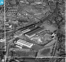
This image shows good detail of the South of Dudley from Blowers Green at the top to Peartree Lane at the bottom left. |
Phil Wild |
Wednesday 11th of June 2014 08:38:24 PM |