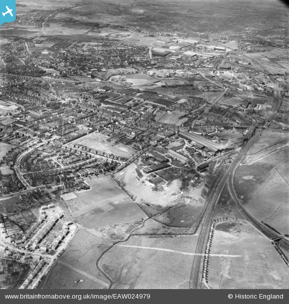
EAW024979 ENGLAND (1949). The F. H. Lloyd and Co James Bridge Steel Works and the surrounding area, Darlaston, 1949. This image was marked by Aerofilms Ltd for photo editing.
© Copyright OpenStreetMap contributors and licensed by the OpenStreetMap Foundation. 2026. Cartography is licensed as CC BY-SA.
Nearby Images (27)
Details
| Title | [EAW024979] The F. H. Lloyd and Co James Bridge Steel Works and the surrounding area, Darlaston, 1949. This image was marked by Aerofilms Ltd for photo editing. |
| Reference | EAW024979 |
| Date | 21-July-1949 |
| Link | |
| Place name | DARLASTON |
| Parish | |
| District | |
| Country | ENGLAND |
| Easting / Northing | 398857, 296914 |
| Longitude / Latitude | -2.0168660785914, 52.569690323245 |
| National Grid Reference | SO989969 |
Pins

KevTheBusDriver |
Sunday 28th of June 2015 07:57:03 PM |


![[EAW024979] The F. H. Lloyd and Co James Bridge Steel Works and the surrounding area, Darlaston, 1949. This image was marked by Aerofilms Ltd for photo editing.](http://britainfromabove.org.uk/sites/all/libraries/aerofilms-images/public/100x100/EAW/024/EAW024979.jpg)
![[EAW024978] The F. H. Lloyd and Co James Bridge Steel Works and the surrounding area, Darlaston, 1949. This image was marked by Aerofilms Ltd for photo editing.](http://britainfromabove.org.uk/sites/all/libraries/aerofilms-images/public/100x100/EAW/024/EAW024978.jpg)
![[EAW024973] The F. H. Lloyd and Co James Bridge Steel Works and the surrounding area, Darlaston, 1949. This image was marked by Aerofilms Ltd for photo editing.](http://britainfromabove.org.uk/sites/all/libraries/aerofilms-images/public/100x100/EAW/024/EAW024973.jpg)
![[EAW042218] F. H. Lloyd & Co James Bridge Steel Works, Darlaston, 1952. This image has been produced from a damaged negative.](http://britainfromabove.org.uk/sites/all/libraries/aerofilms-images/public/100x100/EAW/042/EAW042218.jpg)
![[EPW057526] F.H. Lloyd & Co James Bridge Steel Works, Darlaston, 1938](http://britainfromabove.org.uk/sites/all/libraries/aerofilms-images/public/100x100/EPW/057/EPW057526.jpg)
![[EAW024983] The F. H. Lloyd and Co James Bridge Steel Works and the surrounding area, Darlaston, 1949. This image was marked by Aerofilms Ltd for photo editing.](http://britainfromabove.org.uk/sites/all/libraries/aerofilms-images/public/100x100/EAW/024/EAW024983.jpg)
![[EAW024981] The F. H. Lloyd and Co James Bridge Steel Works and the surrounding area, Darlaston, from the west, 1949. This image was marked by Aerofilms Ltd for photo editing.](http://britainfromabove.org.uk/sites/all/libraries/aerofilms-images/public/100x100/EAW/024/EAW024981.jpg)
![[EAW024971] The F. H. Lloyd and Co James Bridge Steel Works, Darlaston, 1949. This image was marked by Aerofilms Ltd for photo editing.](http://britainfromabove.org.uk/sites/all/libraries/aerofilms-images/public/100x100/EAW/024/EAW024971.jpg)
![[EAW042210] F. H. Lloyd & Co James Bridge Steel Works, Darlaston, from the south, 1952. This image has been produced from a print.](http://britainfromabove.org.uk/sites/all/libraries/aerofilms-images/public/100x100/EAW/042/EAW042210.jpg)
![[EAW000945] F. H. Lloyd & Co James Bridge Steel Works, Darlaston, 1946](http://britainfromabove.org.uk/sites/all/libraries/aerofilms-images/public/100x100/EAW/000/EAW000945.jpg)
![[EAW000947] F. H. Lloyd & Co James Bridge Steel Works, Darlaston, 1946](http://britainfromabove.org.uk/sites/all/libraries/aerofilms-images/public/100x100/EAW/000/EAW000947.jpg)
![[EAW042214] F. H. Lloyd & Co James Bridge Steel Works, Darlaston, 1952. This image has been produced from a print marked by Aerofilms Ltd for photo editing.](http://britainfromabove.org.uk/sites/all/libraries/aerofilms-images/public/100x100/EAW/042/EAW042214.jpg)
![[EAW000951] F. H. Lloyd & Co James Bridge Steel Works, Darlaston, 1946](http://britainfromabove.org.uk/sites/all/libraries/aerofilms-images/public/100x100/EAW/000/EAW000951.jpg)
![[EAW024972] The F. H. Lloyd and Co James Bridge Steel Works, Darlaston, 1949. This image was marked by Aerofilms Ltd for photo editing.](http://britainfromabove.org.uk/sites/all/libraries/aerofilms-images/public/100x100/EAW/024/EAW024972.jpg)
![[EPW057525] F.H. Lloyd & Co James Bridge Steel Works, Darlaston, 1938](http://britainfromabove.org.uk/sites/all/libraries/aerofilms-images/public/100x100/EPW/057/EPW057525.jpg)
![[EPW057524] F.H. Lloyd & Co James Bridge Steel Works, Darlaston, 1938](http://britainfromabove.org.uk/sites/all/libraries/aerofilms-images/public/100x100/EPW/057/EPW057524.jpg)
![[EAW042208] F. H. Lloyd & Co James Bridge Steel Works, Darlaston, 1952. This image has been produced from a print.](http://britainfromabove.org.uk/sites/all/libraries/aerofilms-images/public/100x100/EAW/042/EAW042208.jpg)
![[EPW057527] F.H. Lloyd & Co James Bridge Steel Works, Darlaston, 1938](http://britainfromabove.org.uk/sites/all/libraries/aerofilms-images/public/100x100/EPW/057/EPW057527.jpg)
![[EAW000948] F. H. Lloyd & Co James Bridge Steel Works, Darlaston, 1946](http://britainfromabove.org.uk/sites/all/libraries/aerofilms-images/public/100x100/EAW/000/EAW000948.jpg)
![[EAW042211] F. H. Lloyd & Co James Bridge Steel Works, Darlaston, 1952. This image has been produced from a print marked by Aerofilms Ltd for photo editing.](http://britainfromabove.org.uk/sites/all/libraries/aerofilms-images/public/100x100/EAW/042/EAW042211.jpg)
![[EAW000949] F. H. Lloyd & Co James Bridge Steel Works, Darlaston, 1946](http://britainfromabove.org.uk/sites/all/libraries/aerofilms-images/public/100x100/EAW/000/EAW000949.jpg)
![[EAW000950] F. H. Lloyd & Co James Bridge Steel Works, Darlaston, 1946](http://britainfromabove.org.uk/sites/all/libraries/aerofilms-images/public/100x100/EAW/000/EAW000950.jpg)
![[EAW042206] F. H. Lloyd & Co James Bridge Steel Works, Darlaston, 1952. This image has been produced from a print marked by Aerofilms Ltd for photo editing.](http://britainfromabove.org.uk/sites/all/libraries/aerofilms-images/public/100x100/EAW/042/EAW042206.jpg)
![[EAW042207] F. H. Lloyd & Co James Bridge Steel Works, Darlaston, 1952. This image has been produced from a print marked by Aerofilms Ltd for photo editing.](http://britainfromabove.org.uk/sites/all/libraries/aerofilms-images/public/100x100/EAW/042/EAW042207.jpg)
![[EPW057529] F.H. Lloyd & Co James Bridge Steel Works, Darlaston, 1938](http://britainfromabove.org.uk/sites/all/libraries/aerofilms-images/public/100x100/EPW/057/EPW057529.jpg)
![[EAW042213] F. H. Lloyd & Co James Bridge Steel Works, Darlaston, from the south, 1952. This image has been produced from a print marked by Aerofilms Ltd for photo editing.](http://britainfromabove.org.uk/sites/all/libraries/aerofilms-images/public/100x100/EAW/042/EAW042213.jpg)
![[EAW024980] The F. H. Lloyd and Co James Bridge Steel Works and the surrounding area, Darlaston, from the south, 1949. This image was marked by Aerofilms Ltd for photo editing.](http://britainfromabove.org.uk/sites/all/libraries/aerofilms-images/public/100x100/EAW/024/EAW024980.jpg)