
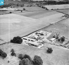
EAW024375 ENGLAND (1949). Manor Farm, East Wellow, 1949. This image was marked by Aerofilms Ltd for photo editing.

© Copyright OpenStreetMap contributors and licensed by the OpenStreetMap Foundation. 2026. Cartography is licensed as CC BY-SA.
Nearby Images (11)
EAW024375

EAW024373

EAW043275

EAW043277

EAW043280

EAW043278

EAW043276

EAW043279

EAW024374

EAW024372

EAW043281

Details
| Title | [EAW024375] Manor Farm, East Wellow, 1949. This image was marked by Aerofilms Ltd for photo editing. |
| Reference | EAW024375 |
| Date | 6-July-1949 |
| Link | |
| Place name | EAST WELLOW |
| Parish | WELLOW |
| District | |
| Country | ENGLAND |
| Easting / Northing | 430448, 120311 |
| Longitude / Latitude | -1.5662158986365, 50.980856928872 |
| National Grid Reference | SU304203 |
Pins

chainbull |
Friday 25th of July 2014 11:02:01 PM |
User Comment Contributions
Great photo |

Christopher |
Saturday 21st of December 2013 08:21:27 PM |