
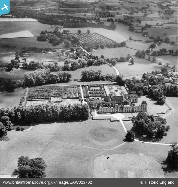
EAW023702 ENGLAND (1949). Penshurst Place, Penshurst, 1949
© Copyright OpenStreetMap contributors and licensed by the OpenStreetMap Foundation. 2026. Cartography is licensed as CC BY-SA.
Nearby Images (4)
EAW023702

EAW023699

EAW023701

EAW023698

Details
| Title | [EAW023702] Penshurst Place, Penshurst, 1949 |
| Reference | EAW023702 |
| Date | 12-June-1949 |
| Link | |
| Place name | PENSHURST |
| Parish | PENSHURST |
| District | |
| Country | ENGLAND |
| Easting / Northing | 552838, 143918 |
| Longitude / Latitude | 0.18661067810187, 51.173526549355 |
| National Grid Reference | TQ528439 |
Pins

Matt Aldred edob.mattaldred.com |
Friday 1st of January 2021 10:16:57 PM | |
|
Matt Aldred edob.mattaldred.com |
Friday 1st of January 2021 10:16:45 PM | |

jrussill |
Thursday 11th of December 2014 06:55:21 PM | |
|
jrussill |
Thursday 11th of December 2014 06:54:43 PM | |

Alan McFaden |
Tuesday 24th of December 2013 09:56:54 PM | |
|
Alan McFaden |
Tuesday 24th of December 2013 09:56:07 PM |


User Comment Contributions

Penshurst pillboxes |
jrussill |
Thursday 11th of December 2014 06:57:12 PM |