
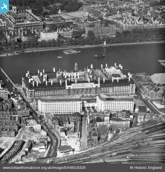
EAW018328 ENGLAND (1948). The County Hall, Lambeth, 1948. This image has been produced from a print.
© Copyright OpenStreetMap contributors and licensed by the OpenStreetMap Foundation. 2026. Cartography is licensed as CC BY-SA.
Nearby Images (45)
EAW018328

EPW060606

EPW060605

EPW019014

EAW034734

EPW008116

EPW005603

EPW060604

EPW025120

EAW033385

EAW033386

EAW034736

EAW034712

EAW034978

EAW034928

EAW034673

EAW034929

EAW042628

EAW021428

EAW034672

EAW034682

EAW035663

EAW034923

EAW034684

EAW035669

EAW034735

EAW048067

EAW035702

EAW031794

EAW035176

EAW046363

EAW047025

EAW048070

EAW031789

EPW055303

EAW043630

EAW034927

EPW031872

EAW035147
 under construction, Lambeth, 1951. This image has been produced from a print.")
EAW035654

EAW034713

EAW035660

EAW031791

EPW009111

EAW021430

Details
| Title | [EAW018328] The County Hall, Lambeth, 1948. This image has been produced from a print. |
| Reference | EAW018328 |
| Date | 24-August-1948 |
| Link | |
| Place name | LAMBETH |
| Parish | |
| District | |
| Country | ENGLAND |
| Easting / Northing | 530693, 179788 |
| Longitude / Latitude | -0.11684615314724, 51.50141480055 |
| National Grid Reference | TQ307798 |
Pins

brianbeckett |
Friday 22nd of May 2020 09:02:00 PM | |
|
ken |
Wednesday 29th of July 2015 10:31:00 AM | |
|
ken |
Wednesday 29th of July 2015 10:29:54 AM | |
|
brianbeckett |
Tuesday 16th of September 2014 04:52:47 PM |