
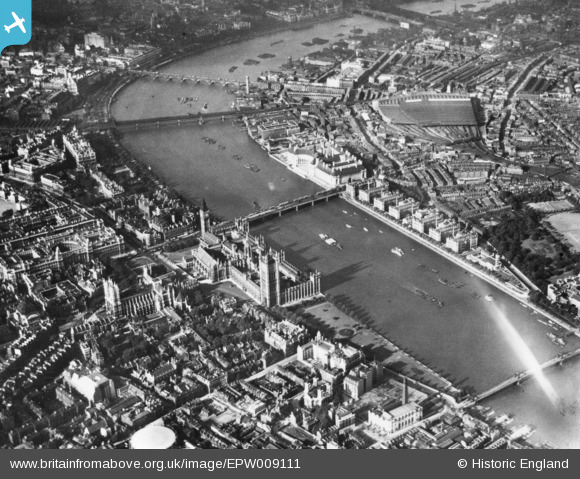
EPW009111 ENGLAND (1923). Whitehall, Westminster, 1923. This image has been produced from a print.
© Copyright OpenStreetMap contributors and licensed by the OpenStreetMap Foundation. 2026. Cartography is licensed as CC BY-SA.
Nearby Images (48)
EPW009111

EAW001431

EAW021431

EAW048064

EAW021428

EPW006160

EAW043618

EAW049402

EAW030304

EPW006166

EAW016647

EPW030095

EAW036810

EAW016646

EAW043616

EAW053008

EAW022164

EAW048066

EAW029480

EAW022167

EPW037969

EPW037980

EAW018329

EPW025120

EAW033386

EAW029581

EPW060793

EPW005603

EAW034976

EAW022163

EAW029833

EAW043614

EAW022166

EAW033384

EAW043609

EPW030094

EAW005241

EAW043638

EAW034734

EAW053009

EAW048065

EAW034980

EPW008116

EPW060604

EAW043617

EAW034736

EAW034712

EPW059350

Details
| Title | [EPW009111] Whitehall, Westminster, 1923. This image has been produced from a print. |
| Reference | EPW009111 |
| Date | 1923 |
| Link | |
| Place name | WESTMINSTER |
| Parish | |
| District | |
| Country | ENGLAND |
| Easting / Northing | 530444, 179634 |
| Longitude / Latitude | -0.1204888675491, 51.500088231836 |
| National Grid Reference | TQ304796 |
Pins
Be the first to add a comment to this image!