
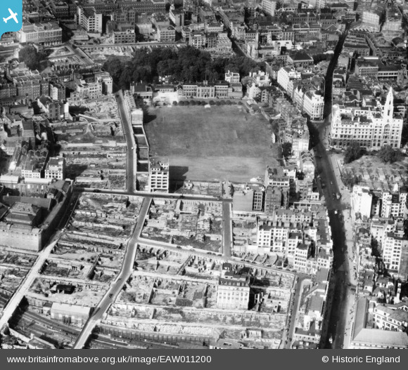
EAW011200 ENGLAND (1947). The New Artillery Ground and surrounding cleared sites following bomb damage, St Luke's, 1947
© Copyright OpenStreetMap contributors and licensed by the OpenStreetMap Foundation. 2026. Cartography is licensed as CC BY-SA.
Nearby Images (10)
EAW011200

EAW000514

EAW011123

EAW011124

EAW011217

EPW053665

EAW011201

EPW053666

EAW011199

EAW011366

Details
| Title | [EAW011200] The New Artillery Ground and surrounding cleared sites following bomb damage, St Luke's, 1947 |
| Reference | EAW011200 |
| Date | 30-September-1947 |
| Link | |
| Place name | ST LUKE'S |
| Parish | |
| District | |
| Country | ENGLAND |
| Easting / Northing | 532672, 181978 |
| Longitude / Latitude | -0.087523461871423, 51.520636235299 |
| National Grid Reference | TQ327820 |
Pins

Smudger |
Wednesday 23rd of October 2024 05:26:31 PM | |

Alan McFaden |
Thursday 20th of November 2014 09:16:25 AM | |

Class31 |
Tuesday 8th of July 2014 05:31:18 PM | |
|
Class31 |
Tuesday 8th of July 2014 05:29:55 PM | |
|
Class31 |
Tuesday 8th of July 2014 05:08:35 PM | |
|
Alan McFaden |
Friday 23rd of May 2014 06:10:58 PM | |
|
Alan McFaden |
Friday 23rd of May 2014 06:10:19 PM | |
|
Alan McFaden |
Friday 23rd of May 2014 06:09:27 PM | |
|
Class31 |
Monday 12th of May 2014 05:26:31 PM | |
|
Class31 |
Monday 12th of May 2014 05:26:08 PM |


User Comment Contributions
View is looking north. |
Class31 |
Monday 12th of May 2014 05:26:55 PM |