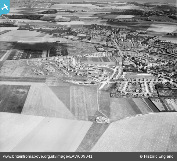
EAW009041 ENGLAND (1947). The residential area at Newington (surrounding Melbourne Avenue) under construction and the surrounding area, Ramsgate, 1947
© Copyright OpenStreetMap contributors and licensed by the OpenStreetMap Foundation. 2025. Cartography is licensed as CC BY-SA.
Nearby Images (5)
Details
| Title | [EAW009041] The residential area at Newington (surrounding Melbourne Avenue) under construction and the surrounding area, Ramsgate, 1947 |
| Reference | EAW009041 |
| Date | 12-August-1947 |
| Link | |
| Place name | RAMSGATE |
| Parish | RAMSGATE |
| District | |
| Country | ENGLAND |
| Easting / Northing | 636517, 166218 |
| Longitude / Latitude | 1.3966737708763, 51.345243822609 |
| National Grid Reference | TR365662 |
Pins
Be the first to add a comment to this image!


![[EAW009041] The residential area at Newington (surrounding Melbourne Avenue) under construction and the surrounding area, Ramsgate, 1947](http://britainfromabove.org.uk/sites/all/libraries/aerofilms-images/public/100x100/EAW/009/EAW009041.jpg)
![[EAW009035] The residential area at Newington (surrounding Melbourne Avenue) under construction and the surrounding area, Ramsgate, 1947](http://britainfromabove.org.uk/sites/all/libraries/aerofilms-images/public/100x100/EAW/009/EAW009035.jpg)
![[EAW009036] The residential area at Newington (surrounding Melbourne Avenue) under construction, Ramsgate, 1947](http://britainfromabove.org.uk/sites/all/libraries/aerofilms-images/public/100x100/EAW/009/EAW009036.jpg)
![[EAW009040] The residential area at Newington (surrounding Melbourne Avenue) under construction, Ramsgate, 1947](http://britainfromabove.org.uk/sites/all/libraries/aerofilms-images/public/100x100/EAW/009/EAW009040.jpg)
![[EAW009032] The residential area at Newington (surrounding Melbourne Avenue) under construction, Ramsgate, 1947](http://britainfromabove.org.uk/sites/all/libraries/aerofilms-images/public/100x100/EAW/009/EAW009032.jpg)