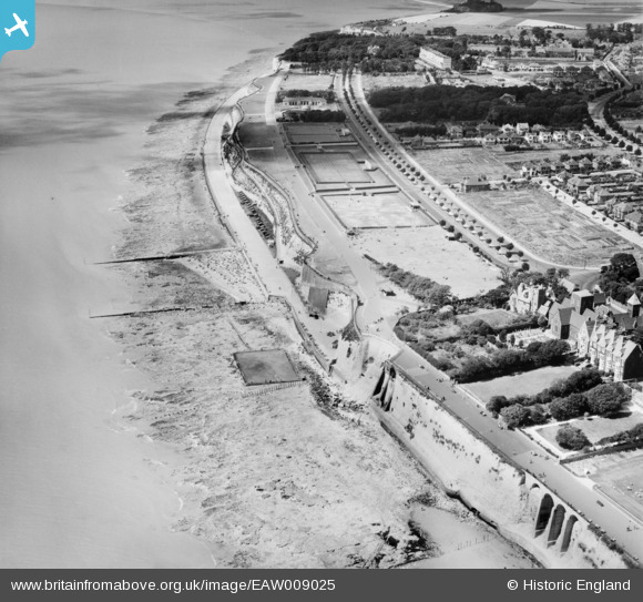
EAW009025 ENGLAND (1947). The Royal Esplanade, West Cliff and the seafront, Ramsgate, 1947
    © Copyright OpenStreetMap contributors and licensed by the OpenStreetMap Foundation. 2025. Cartography is licensed as CC BY-SA.
  
Nearby Images (11)
Details
| Title | [EAW009025] The Royal Esplanade, West Cliff and the seafront, Ramsgate, 1947 | 
| Reference | EAW009025 | 
| Date | 12-August-1947 | 
| Link | |
| Place name | RAMSGATE | 
| Parish | RAMSGATE | 
| District | |
| Country | ENGLAND | 
| Easting / Northing | 637596, 164203 | 
| Longitude / Latitude | 1.4107959857873, 51.326705583706 | 
| National Grid Reference | TR376642 | 
Pins
|  WW2 Pillbox TBC |   Sparky | Thursday 6th of July 2017 09:22:40 PM | 
 
             
  ![[EAW009025] The Royal Esplanade, West Cliff and the seafront, Ramsgate, 1947](http://britainfromabove.org.uk/sites/all/libraries/aerofilms-images/public/100x100/EAW/009/EAW009025.jpg) 
  
                                          ![[EPW052895] The town, Ramsgate, from the south-west, 1937](http://britainfromabove.org.uk/sites/all/libraries/aerofilms-images/public/100x100/EPW/052/EPW052895.jpg) 
 ![[EPW052887] The town and seafront, Ramsgate, from the south-west, 1937. This image has been produced from a print.](http://britainfromabove.org.uk/sites/all/libraries/aerofilms-images/public/100x100/EPW/052/EPW052887.jpg) 
 ![[EAW009021] West Cliff, Grange Road and the surrounding area, Ramsgate, 1947](http://britainfromabove.org.uk/sites/all/libraries/aerofilms-images/public/100x100/EAW/009/EAW009021.jpg) 
 ![[EPW000097] West Cliff, Ramsgate, from the south-east, 1920](http://britainfromabove.org.uk/sites/all/libraries/aerofilms-images/public/100x100/EPW/000/EPW000097.jpg) 
 ![[EPW000090] The Royal Crescent and Cliff Promenade, Ramsgate, from the south-west, 1920. This image has been produced from a copy-negative.](http://britainfromabove.org.uk/sites/all/libraries/aerofilms-images/public/100x100/EPW/000/EPW000090.jpg) 
 ![[EPW013300] Royal Esplanade looking towards Royal Harbour and the town, Ramsgate, 1925. This image has been produced from a print.](http://britainfromabove.org.uk/sites/all/libraries/aerofilms-images/public/100x100/EPW/013/EPW013300.jpg) 
 ![[EAW006625] The Royal Harbour and town, Ramsgate, from the south-west, 1947](http://britainfromabove.org.uk/sites/all/libraries/aerofilms-images/public/100x100/EAW/006/EAW006625.jpg) 
 ![[EPW013299] Grange Road and environs, Ramsgate, 1925. This image has been produced from a copy-negative.](http://britainfromabove.org.uk/sites/all/libraries/aerofilms-images/public/100x100/EPW/013/EPW013299.jpg) 
 ![[EAW009023] West Cliff, Royal Crescent and the surrounding area, Ramsgate, 1947](http://britainfromabove.org.uk/sites/all/libraries/aerofilms-images/public/100x100/EAW/009/EAW009023.jpg) 
 ![[EPW000094] The Royal Crescent, Ramsgate, 1920](http://britainfromabove.org.uk/sites/all/libraries/aerofilms-images/public/100x100/EPW/000/EPW000094.jpg)