
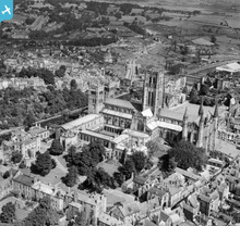
EAW007837 ENGLAND (1947). The Cathedral Church of Christ and St Mary the Virgin, Durham, 1947

© Copyright OpenStreetMap contributors and licensed by the OpenStreetMap Foundation. 2026. Cartography is licensed as CC BY-SA.
Nearby Images (24)
EAW007837

EPW016377

EPW016378

EAW014484

EAW007839

EAW017465

EAW014485

EPW016376

EAW007838

EAW005521

EAW014482

EAW005524

EAW005520

EAW017463

EAW014483

EAW005523

EPW026650

EAW014481

EPW026591

EAW005522

EPW026649

EPW026648

EAW007832

EAW014480

Details
| Title | [EAW007837] The Cathedral Church of Christ and St Mary the Virgin, Durham, 1947 |
| Reference | EAW007837 |
| Date | 27-June-1947 |
| Link | |
| Place name | DURHAM |
| Parish | |
| District | |
| Country | ENGLAND |
| Easting / Northing | 427323, 542135 |
| Longitude / Latitude | -1.5752172600408, 54.773289995408 |
| National Grid Reference | NZ273421 |
Pins

Paul McK |
Saturday 5th of November 2022 10:24:41 PM | |
|
mildertduck |
Monday 7th of January 2019 10:54:44 PM | |

Class31 |
Thursday 8th of May 2014 08:37:12 PM | |
|
billandjm |
Sunday 22nd of December 2013 03:25:52 PM | |
|
billandjm |
Sunday 22nd of December 2013 03:23:52 PM | |
|
billandjm |
Sunday 22nd of December 2013 03:21:46 PM | |
|
billandjm |
Sunday 22nd of December 2013 03:18:44 PM |
User Comment Contributions
The County Hospital is shown at the top left of this picture of Durham. |
history group |
Monday 2nd of December 2013 09:25:03 PM |