
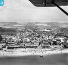
EAW007606 ENGLAND (1947). The town and seafront, Dover, from the south-east, 1947

© Copyright OpenStreetMap contributors and licensed by the OpenStreetMap Foundation. 2026. Cartography is licensed as CC BY-SA.
Nearby Images (15)
EAW007606

EPW000579

EAW007610

EPW035420

EPW039376

EPW039374

EPW019057

EAW007612

EAW007618

EPW039375

EAW007613

EPW038155

EPW000356

EAW007611

EAW020180

Details
| Title | [EAW007606] The town and seafront, Dover, from the south-east, 1947 |
| Reference | EAW007606 |
| Date | 28-June-1947 |
| Link | |
| Place name | DOVER |
| Parish | DOVER |
| District | |
| Country | ENGLAND |
| Easting / Northing | 632054, 141126 |
| Longitude / Latitude | 1.3164442150532, 51.1218132631 |
| National Grid Reference | TR321411 |
Pins

Doverpast |
Sunday 24th of December 2017 06:31:42 PM | |
|
jrussill |
Wednesday 8th of January 2014 07:06:11 PM | |
Judging by the shadows under them I'd say they are deck chairs. |
cptpies |
Thursday 9th of January 2014 09:01:57 AM |
I think they are deck chairs too there are many arranged in front of the hotel in the 1931 imagery |
Al |
Thursday 9th of January 2014 10:15:53 AM |
User Comment Contributions
WW2 Cylinders? |
jrussill |
Wednesday 8th of January 2014 07:06:51 PM |