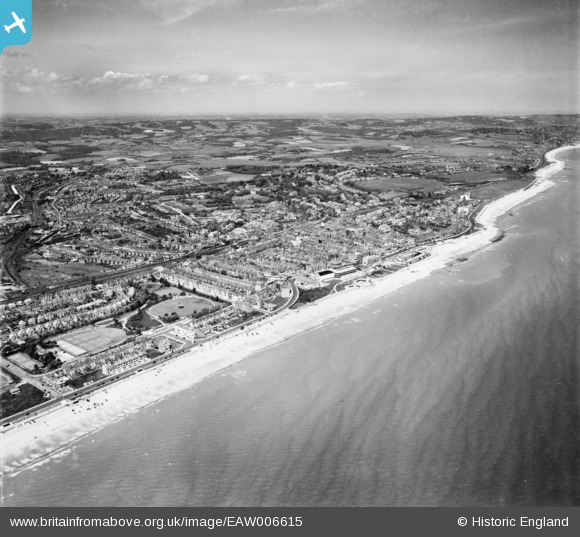
EAW006615 ENGLAND (1947). The seafront and town, Bexhill, from the south, 1947
© Copyright OpenStreetMap contributors and licensed by the OpenStreetMap Foundation. 2026. Cartography is licensed as CC BY-SA.
Nearby Images (10)
Details
| Title | [EAW006615] The seafront and town, Bexhill, from the south, 1947 |
| Reference | EAW006615 |
| Date | 27-May-1947 |
| Link | |
| Place name | BEXHILL |
| Parish | |
| District | |
| Country | ENGLAND |
| Easting / Northing | 573988, 106853 |
| Longitude / Latitude | 0.47114504973231, 50.834459396945 |
| National Grid Reference | TQ740069 |
Pins

redmist |
Monday 27th of November 2023 09:11:38 PM | |

redmist |
Monday 27th of November 2023 09:09:10 PM | |

Post-war prefabs |
Thursday 28th of November 2019 03:17:17 PM | |

leigh kennedy |
Tuesday 21st of June 2016 03:24:44 AM | |

John W |
Saturday 11th of June 2016 05:23:50 PM | |

John W |
Saturday 11th of June 2016 05:22:35 PM | |

John W |
Saturday 11th of June 2016 05:21:58 PM | |

John W |
Saturday 11th of June 2016 05:20:05 PM | |

John W |
Saturday 11th of June 2016 05:18:54 PM | |

Alan McFaden |
Thursday 12th of June 2014 12:29:51 PM | |

Alan McFaden |
Thursday 12th of June 2014 12:28:57 PM | |

Alan McFaden |
Thursday 12th of June 2014 12:26:41 PM | |

Alan McFaden |
Thursday 12th of June 2014 12:26:02 PM |


![[EAW006615] The seafront and town, Bexhill, from the south, 1947](http://britainfromabove.org.uk/sites/all/libraries/aerofilms-images/public/100x100/EAW/006/EAW006615.jpg)
![[EPW000697] Bexhill, from the south-west, 1920](http://britainfromabove.org.uk/sites/all/libraries/aerofilms-images/public/100x100/EPW/000/EPW000697.jpg)
![[EPW035329] The Colonnade and seafront, Bexhill, 1931](http://britainfromabove.org.uk/sites/all/libraries/aerofilms-images/public/100x100/EPW/035/EPW035329.jpg)
![[EPW039350] West Parade and the seafront, Bexhill, from the south-west, 1932](http://britainfromabove.org.uk/sites/all/libraries/aerofilms-images/public/100x100/EPW/039/EPW039350.jpg)
![[EPW035331] West Parade and environs, Bexhill, from the west, 1931](http://britainfromabove.org.uk/sites/all/libraries/aerofilms-images/public/100x100/EPW/035/EPW035331.jpg)
![[EPW035330] The Colonnade and environs, Bexhill, 1931](http://britainfromabove.org.uk/sites/all/libraries/aerofilms-images/public/100x100/EPW/035/EPW035330.jpg)
![[EPW026233] The Colonnade, Metropole Hotel and environs, Bexhill, 1929](http://britainfromabove.org.uk/sites/all/libraries/aerofilms-images/public/100x100/EPW/026/EPW026233.jpg)
![[EPW026222] The Colonnade, Metropole Hotel and environs, Bexhill, 1929](http://britainfromabove.org.uk/sites/all/libraries/aerofilms-images/public/100x100/EPW/026/EPW026222.jpg)
![[EPW039349] The Colonnade and Metropole Hotel, Bexhill, 1932](http://britainfromabove.org.uk/sites/all/libraries/aerofilms-images/public/100x100/EPW/039/EPW039349.jpg)
![[EPW000120] The Colonnade, Bexhill, 1920](http://britainfromabove.org.uk/sites/all/libraries/aerofilms-images/public/100x100/EPW/000/EPW000120.jpg)


