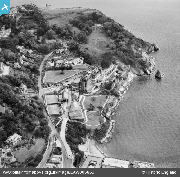
EAW005865 ENGLAND (1947). Park Hill Road and the Imperial Hotel, Torquay, 1947
© Copyright OpenStreetMap contributors and licensed by the OpenStreetMap Foundation. 2026. Cartography is licensed as CC BY-SA.
Nearby Images (21)
Details
| Title | [EAW005865] Park Hill Road and the Imperial Hotel, Torquay, 1947 |
| Reference | EAW005865 |
| Date | 15-May-1947 |
| Link | |
| Place name | TORQUAY |
| Parish | |
| District | |
| Country | ENGLAND |
| Easting / Northing | 292100, 63015 |
| Longitude / Latitude | -3.5201910618774, 50.456430085351 |
| National Grid Reference | SX921630 |
Pins

redmist |
Thursday 9th of July 2020 04:59:02 PM | |

redmist |
Thursday 9th of July 2020 04:51:28 PM |


![[EAW005865] Park Hill Road and the Imperial Hotel, Torquay, 1947](http://britainfromabove.org.uk/sites/all/libraries/aerofilms-images/public/100x100/EAW/005/EAW005865.jpg)
![[EAW005873] Park Hill Road and the Imperial Hotel, Torquay, 1947](http://britainfromabove.org.uk/sites/all/libraries/aerofilms-images/public/100x100/EAW/005/EAW005873.jpg)
![[EAW005872] The Imperial Hotel, Torquay, 1947. This image was marked by Aerofilms Ltd for photo editing.](http://britainfromabove.org.uk/sites/all/libraries/aerofilms-images/public/100x100/EAW/005/EAW005872.jpg)
![[EAW005866] The Imperial Hotel, Torquay, 1947](http://britainfromabove.org.uk/sites/all/libraries/aerofilms-images/public/100x100/EAW/005/EAW005866.jpg)
![[EAW005869] The Imperial Hotel, Park Hill Road and the New Harbour, Torquay, 1947](http://britainfromabove.org.uk/sites/all/libraries/aerofilms-images/public/100x100/EAW/005/EAW005869.jpg)
![[EAW005870] The Imperial Hotel, Park Hill and environs, Torquay, from the south-west, 1947](http://britainfromabove.org.uk/sites/all/libraries/aerofilms-images/public/100x100/EAW/005/EAW005870.jpg)
![[EAW005874] Park Hill Road and the Imperial Hotel, Torquay, 1947. This image was marked by Aerofilms Ltd for photo editing.](http://britainfromabove.org.uk/sites/all/libraries/aerofilms-images/public/100x100/EAW/005/EAW005874.jpg)
![[EAW005867] The Imperial Hotel, Torquay, 1947. This image was marked by Aerofilms Ltd for photo editing.](http://britainfromabove.org.uk/sites/all/libraries/aerofilms-images/public/100x100/EAW/005/EAW005867.jpg)
![[EAW005868] The Imperial Hotel, Torquay, 1947. This image was marked by Aerofilms Ltd for photo editing.](http://britainfromabove.org.uk/sites/all/libraries/aerofilms-images/public/100x100/EAW/005/EAW005868.jpg)
![[EAW030901] The Princes Hotel, Beacon Cove and the Imperial Hotel, Wellswood, 1950. This image was marked by Aerofilms Ltd for photo editing.](http://britainfromabove.org.uk/sites/all/libraries/aerofilms-images/public/100x100/EAW/030/EAW030901.jpg)
![[EPR000338] The Imperial Hotel, Torquay, 1934. This image was marked by Aero Pictorial Ltd for photo editing.](http://britainfromabove.org.uk/sites/all/libraries/aerofilms-images/public/100x100/EPR/000/EPR000338.jpg)
![[EAW005871] The harbours, Imperial Hotel and Wellswood, Torquay, from the south, 1947](http://britainfromabove.org.uk/sites/all/libraries/aerofilms-images/public/100x100/EAW/005/EAW005871.jpg)
![[EAW030902] The Princes Hotel and Beacon Cove, Wellswood, 1950. This image was marked by Aerofilms Ltd for photo editing.](http://britainfromabove.org.uk/sites/all/libraries/aerofilms-images/public/100x100/EAW/030/EAW030902.jpg)
![[EAW030899] The Princes Hotel, Wellswood, 1950. This image was marked by Aerofilms Ltd for photo editing.](http://britainfromabove.org.uk/sites/all/libraries/aerofilms-images/public/100x100/EAW/030/EAW030899.jpg)
![[EAW030900] The Princes Hotel overlooking the Old Harbour, Wellswood, 1950. This image was marked by Aerofilms Ltd for photo editing.](http://britainfromabove.org.uk/sites/all/libraries/aerofilms-images/public/100x100/EAW/030/EAW030900.jpg)
![[EAW031976] Beacon Cove, Torquay, 1950](http://britainfromabove.org.uk/sites/all/libraries/aerofilms-images/public/100x100/EAW/031/EAW031976.jpg)
![[EAW030898] The Princes Hotel, Wellswood, 1950. This image was marked by Aerofilms Ltd for photo editing.](http://britainfromabove.org.uk/sites/all/libraries/aerofilms-images/public/100x100/EAW/030/EAW030898.jpg)
![[EAW030903] The Princes Hotel, Wellswood, 1950. This image was marked by Aerofilms Ltd for photo editing.](http://britainfromabove.org.uk/sites/all/libraries/aerofilms-images/public/100x100/EAW/030/EAW030903.jpg)
![[EPW023716] The Marine Spa and Beacon Cove, Torquay, 1928](http://britainfromabove.org.uk/sites/all/libraries/aerofilms-images/public/100x100/EPW/023/EPW023716.jpg)
![[EAW005875] The harbours and the town, Torquay, from the south-east, 1947](http://britainfromabove.org.uk/sites/all/libraries/aerofilms-images/public/100x100/EAW/005/EAW005875.jpg)
![[EAW011687] Beacon Quay and the harbours, Torquay, 1947](http://britainfromabove.org.uk/sites/all/libraries/aerofilms-images/public/100x100/EAW/011/EAW011687.jpg)