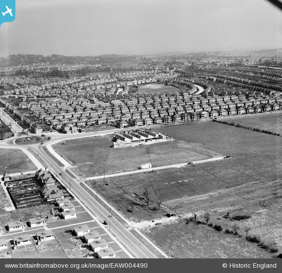
EAW004490 ENGLAND (1947). Victoria Road and housing estate to the south of Eastcote Lane, South Ruislip, from the west, 1947
    © Copyright OpenStreetMap contributors and licensed by the OpenStreetMap Foundation. 2025. Cartography is licensed as CC BY-SA.
  
Details
| Title | [EAW004490] Victoria Road and housing estate to the south of Eastcote Lane, South Ruislip, from the west, 1947 | 
| Reference | EAW004490 | 
| Date | 14-May-1947 | 
| Link | |
| Place name | SOUTH RUISLIP | 
| Parish | |
| District | |
| Country | ENGLAND | 
| Easting / Northing | 512127, 185513 | 
| Longitude / Latitude | -0.38241627826614, 51.556865245651 | 
| National Grid Reference | TQ121855 | 
Pins
|  73 Walton Avenue |   alec | Monday 24th of August 2020 02:25:20 AM | 
|  world war 2 air raid siren |   mick | Friday 27th of March 2020 06:42:59 AM | 
|  These structures are part of the disused Northolt Park Racecourse.
t was opened in 1929 and closed about ten years later at the outbreak of WW2 during which time it was used as a storage area for the Army Ordnance Depot at Long Drive. 
After the war, attempts tor revive it as a racecourse never really came to anything and it was eventually acquired by the local authority for housing development. |   The Laird | Saturday 15th of October 2016 07:37:26 PM | 
|  Northolt Park station |   The Laird | Friday 4th of March 2016 01:17:46 AM | 
|  The Swan public house, Northolt Park |   The Laird | Friday 4th of March 2016 01:12:41 AM | 
|  Ingersoll Locks factory under construction. |   The Laird | Thursday 3rd of March 2016 06:18:14 PM | 
|  The Eastcote Arms pub. |   The Laird | Wednesday 29th of April 2015 04:17:19 PM | 
|  Prefabs |   The Laird | Wednesday 29th of April 2015 04:15:47 PM | 
 
             
  ![[EAW004490] Victoria Road and housing estate to the south of Eastcote Lane, South Ruislip, from the west, 1947](http://britainfromabove.org.uk/sites/all/libraries/aerofilms-images/public/100x100/EAW/004/EAW004490.jpg) 
  
                                          ![[EAW004489] Roundabout at the junction of Victoria Road and Field End Road and environs, South Ruislip, from the south-west, 1947. This image was marked by Aerofilms Ltd for photo editing.](http://britainfromabove.org.uk/sites/all/libraries/aerofilms-images/public/100x100/EAW/004/EAW004489.jpg)