
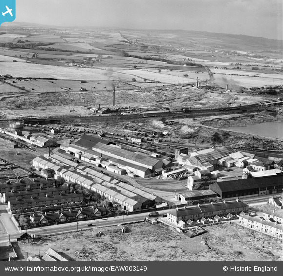
EAW003149 ENGLAND (1946). The Birtley Iron Co Ltd Works and the surrounding countryside, Birtley, from the east, 1946
© Copyright OpenStreetMap contributors and licensed by the OpenStreetMap Foundation. 2026. Cartography is licensed as CC BY-SA.
Nearby Images (12)
EAW003149

EAW003139

EAW003147

EAW003144

EAW003146

EAW003140

EAW003145

EAW003143

EAW003141

EAW003148

EAW003142

EAW003138

Details
| Title | [EAW003149] The Birtley Iron Co Ltd Works and the surrounding countryside, Birtley, from the east, 1946 |
| Reference | EAW003149 |
| Date | 23-October-1946 |
| Link | |
| Place name | BIRTLEY |
| Parish | |
| District | |
| Country | ENGLAND |
| Easting / Northing | 427211, 555076 |
| Longitude / Latitude | -1.5757406358459, 54.889599735929 |
| National Grid Reference | NZ272551 |
Pins

Matt Aldred edob.mattaldred.com |
Monday 8th of March 2021 06:46:17 PM | |

Sparky |
Friday 15th of September 2017 09:34:23 AM | |

JCC |
Saturday 9th of November 2013 12:05:20 AM | |
|
JCC |
Saturday 9th of November 2013 12:04:06 AM | |
|
JCC |
Saturday 9th of November 2013 12:00:57 AM | |
do you know or dose any one else know if there is any photos bewicke main thank you |
ian |
Monday 25th of May 2015 04:09:09 PM |
|
JCC |
Saturday 9th of November 2013 12:00:07 AM | |
|
JCC |
Friday 8th of November 2013 11:56:47 PM |