
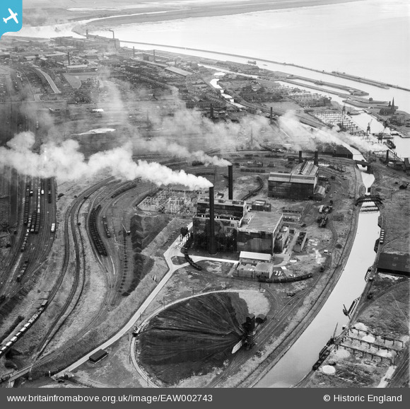
EAW002743 ENGLAND (1946). Percival Lane Power Station, Runcorn, 1946
© Copyright OpenStreetMap contributors and licensed by the OpenStreetMap Foundation. 2026. Cartography is licensed as CC BY-SA.
Nearby Images (14)
EAW002743

EAW002742

EAW002738

EAW016787

EAW005673

EAW002740

EAW002741

EAW002735

EAW005671

EAW005672

EAW005662

EAW002739

EAW005667

EAW005668

Details
| Title | [EAW002743] Percival Lane Power Station, Runcorn, 1946 |
| Reference | EAW002743 |
| Date | 11-September-1946 |
| Link | |
| Place name | RUNCORN |
| Parish | |
| District | |
| Country | ENGLAND |
| Easting / Northing | 349756, 381955 |
| Longitude / Latitude | -2.754553640075, 53.3318491602 |
| National Grid Reference | SJ498820 |
Pins

Bottom Yard |
Saturday 7th of June 2025 04:45:04 PM | |
|
Bottom Yard |
Saturday 7th of June 2025 04:44:06 PM | |
|
Bottom Yard |
Saturday 7th of June 2025 04:42:03 PM | |
|
Bottom Yard |
Sunday 30th of March 2025 04:35:57 PM | |

Sparky |
Wednesday 2nd of August 2017 11:51:13 PM | |
|
MB |
Monday 4th of November 2013 11:26:22 PM | |
|
MB |
Monday 4th of November 2013 11:25:41 PM |