
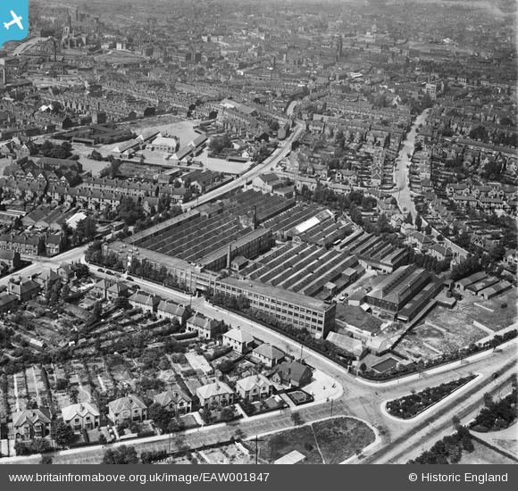
EAW001847 ENGLAND (1946). The J. A. Crabtree and Co Electrical Apparatus Works and the surrounding residential area, Walsall, 1946
© Copyright OpenStreetMap contributors and licensed by the OpenStreetMap Foundation. 2026. Cartography is licensed as CC BY-SA.
Nearby Images (34)
EAW001847

EPW017927

EAW001846

EAW001845

EAW001848

EAW001850

EAW001849

EPW028644

EPW017865

EPW015031

EPW017868

EPW028648

EAW001852

EPW017926

EPW017922

EPW028639

EPW028642

EPW028641

EPW017924

EPW028646

EPW028645

EPW028640

EPW028643

EPW017870

EAW001851

EPW017921

EPW017871

EPW017867

EPW017928

EPW017869

EPW017864

EPW017925

EPW017923

EPW017866

Details
| Title | [EAW001847] The J. A. Crabtree and Co Electrical Apparatus Works and the surrounding residential area, Walsall, 1946 |
| Reference | EAW001847 |
| Date | 12-July-1946 |
| Link | |
| Place name | WALSALL |
| Parish | |
| District | |
| Country | ENGLAND |
| Easting / Northing | 402343, 298543 |
| Longitude / Latitude | -1.9654152319049, 52.584332585519 |
| National Grid Reference | SP023985 |
Pins

Matt Aldred edob.mattaldred.com |
Thursday 7th of March 2024 05:15:17 PM | |

Sparky |
Tuesday 19th of September 2017 09:39:29 PM | |
|
Sparky |
Tuesday 19th of September 2017 09:38:51 PM | |
|
Sparky |
Tuesday 19th of September 2017 09:38:27 PM | |
|
Sparky |
Tuesday 19th of September 2017 09:37:40 PM |