
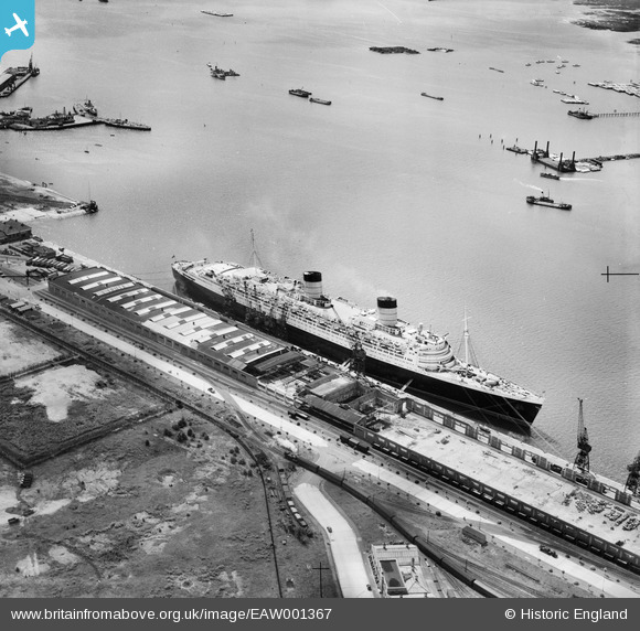
EAW001367 ENGLAND (1946). RMS Queen Elizabeth at the New Docks (Western Docks), Southampton, 1946
© Copyright OpenStreetMap contributors and licensed by the OpenStreetMap Foundation. 2026. Cartography is licensed as CC BY-SA.
Nearby Images (20)
EAW001367
, Southampton, 1946")
EAW035614
 moored alongside the Passenger and Goods Shed No 101, Southampton, 1951")
EAW001364
, Southampton, 1946")
EAW035612
 moored alongside the Passenger and Goods Shed No 101, Southampton, 1951")
EAW001365
, Southampton, from the south-west, 1946")
EAW001362
, Southampton, 1946")
EAW001360
, Southampton, from the north-west, 1946")
EAW035613
 moored alongside the Passenger and Goods Shed No 101, Southampton, 1951")
EAW035610
 moored alongside the Passenger and Goods Shed No 101, Southampton, 1951")
EAW035611
 moored alongside the Passenger and Goods Shed No 101, Southampton, 1951")
EAW001339
, Southampton, from the south-east, 1946")
EAW051599

EAW001363
, Southampton, from the south-west, 1946")
EAW002824
, Southampton, from the south, 1946")
EAW022290
, Southampton, from the south, 1949")
EPW041062

EAW001356
, Southampton, from the north-west, 1946")
EAW001366
, Southampton, 1946")
EAW001343
, Southampton, from the south-east, 1946")
EAW001353
, Southampton, from the north-west, 1946")
Details
| Title | [EAW001367] RMS Queen Elizabeth at the New Docks (Western Docks), Southampton, 1946 |
| Reference | EAW001367 |
| Date | 28-June-1946 |
| Link | |
| Place name | SOUTHAMPTON |
| Parish | |
| District | |
| Country | ENGLAND |
| Easting / Northing | 441195, 111325 |
| Longitude / Latitude | -1.414130311246, 50.899377913408 |
| National Grid Reference | SU412113 |
Pins

redmist |
Tuesday 6th of December 2022 07:39:04 PM | |
|
redmist |
Tuesday 6th of December 2022 07:36:18 PM | |
|
Graham Yaxley |
Monday 5th of January 2015 06:11:17 PM | |
|
Graham Yaxley |
Monday 5th of January 2015 06:08:30 PM |