
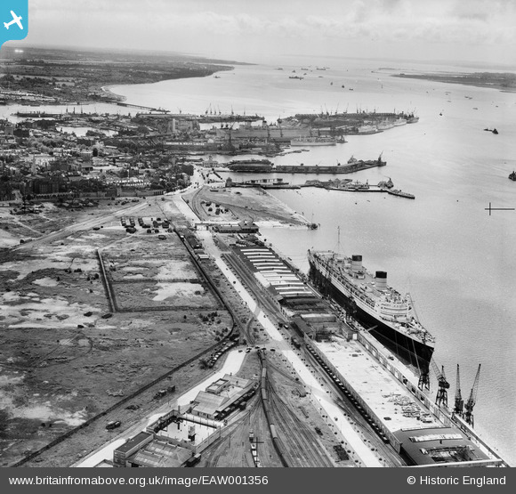
EAW001356 ENGLAND (1946). RMS Queen Elizabeth at the New Docks (Western Docks), Southampton, from the north-west, 1946
© Copyright OpenStreetMap contributors and licensed by the OpenStreetMap Foundation. 2026. Cartography is licensed as CC BY-SA.
Nearby Images (22)
EAW001356
, Southampton, from the north-west, 1946")
EAW001366
, Southampton, 1946")
EPW041062

EAW001365
, Southampton, from the south-west, 1946")
EAW035613
 moored alongside the Passenger and Goods Shed No 101, Southampton, 1951")
EAW001360
, Southampton, from the north-west, 1946")
EAW035611
 moored alongside the Passenger and Goods Shed No 101, Southampton, 1951")
EAW035612
 moored alongside the Passenger and Goods Shed No 101, Southampton, 1951")
EAW022290
, Southampton, from the south, 1949")
EAW035610
 moored alongside the Passenger and Goods Shed No 101, Southampton, 1951")
EAW001364
, Southampton, 1946")
EAW001367
, Southampton, 1946")
EAW035614
 moored alongside the Passenger and Goods Shed No 101, Southampton, 1951")
EAW001363
, Southampton, from the south-west, 1946")
EAW001362
, Southampton, 1946")
EAW001339
, Southampton, from the south-east, 1946")
EAW051599

EAW001353
, Southampton, from the north-west, 1946")
EAW035620

EAW020012

EAW001343
, Southampton, from the south-east, 1946")
EAW035625

Details
| Title | [EAW001356] RMS Queen Elizabeth at the New Docks (Western Docks), Southampton, from the north-west, 1946 |
| Reference | EAW001356 |
| Date | 28-June-1946 |
| Link | |
| Place name | SOUTHAMPTON |
| Parish | |
| District | |
| Country | ENGLAND |
| Easting / Northing | 441262, 111456 |
| Longitude / Latitude | -1.4131626915671, 50.900551205744 |
| National Grid Reference | SU413115 |
Pins

000009 |
Tuesday 20th of November 2018 03:04:21 PM | |

Class31 |
Monday 2nd of November 2015 09:26:20 AM | |
|
Class31 |
Monday 2nd of November 2015 09:24:36 AM | |
|
Class31 |
Monday 2nd of November 2015 09:21:54 AM | |
|
Kevin O'Hare |
Sunday 1st of November 2015 09:50:11 PM |


