
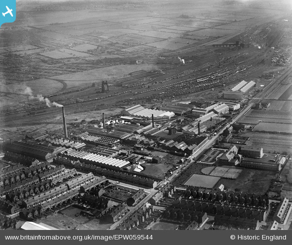
EPW059544 ENGLAND (1938). The British Rope Works on Carr Hill, the Mineral Sidings and environs, Doncaster, 1938
© Copyright OpenStreetMap contributors and licensed by the OpenStreetMap Foundation. 2024. Cartography is licensed as CC BY-SA.
Nearby Images (16)
EPW059544

EPW059545

EPW059546

EPW059547

EPW049318
 and environs, Doncaster, 1935")
EPW049314
 and environs, Doncaster, 1935")
EPW049312
 and environs, Doncaster, 1935")
EPW049311
 and environs, Doncaster, 1935")
EPW049313
 and environs, Doncaster, 1935")
EPW049315
 and environs, Doncaster, 1935")
EPW059550

EPW059551

EPW059548

EPW049316
 and environs, Doncaster, from the south-east, 1935")
EPW059549

EPW049317
 and environs, Doncaster, from the south, 1935")
Details
| Title | [EPW059544] The British Rope Works on Carr Hill, the Mineral Sidings and environs, Doncaster, 1938 |
| Reference | EPW059544 |
| Date | 22-September-1938 |
| Link | |
| Place name | DONCASTER |
| Parish | |
| District | |
| Country | ENGLAND |
| Easting / Northing | 457257, 401663 |
| Longitude / Latitude | -1.1365573746335, 53.508283398574 |
| National Grid Reference | SE573017 |
Pins
 Rick |
Monday 19th of January 2015 04:42:02 PM | |
Red brick viaduct, allowed 1000's of workers to walk/cycle down from N/E areas and town and cross all the railway lines to get to mining supplies instead of everyone going balby rd/carrhill. I think it was blown up in the 70's during work hrs, many cars damaged and some injuries. The good old days! |
jonron |
Saturday 5th of August 2023 03:25:22 AM |
User Comment Contributions
This viaduct can be seen with its girder spans in photograph EPW 012768. |
Rick |
Monday 9th of February 2015 03:00:23 PM |
Looking at a 1931 OS map, this viaduct ran across the railway from Decoy Bank to Carr Hill and was known as Red Bank Viaduct; it seems a awfully large structure to use as a pedestrian walkway. |
Rick |
Tuesday 20th of January 2015 05:38:34 PM |


