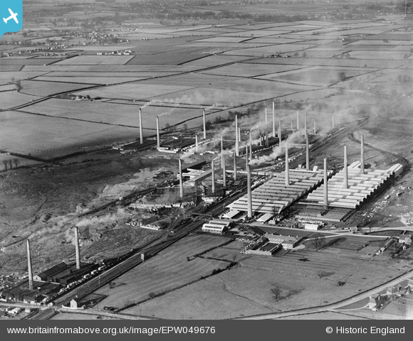
EPW049676 ENGLAND (1936). The Pillinge Brick Works and environs, Stewartby, 1936
© Copyright OpenStreetMap contributors and licensed by the OpenStreetMap Foundation. 2024. Cartography is licensed as CC BY-SA.
Nearby Images (27)
Details
| Title | [EPW049676] The Pillinge Brick Works and environs, Stewartby, 1936 |
| Reference | EPW049676 |
| Date | February-1936 |
| Link | |
| Place name | STEWARTBY |
| Parish | STEWARTBY |
| District | |
| Country | ENGLAND |
| Easting / Northing | 501639, 242874 |
| Longitude / Latitude | -0.51682770601394, 52.074473314851 |
| National Grid Reference | TL016429 |
Pins
Be the first to add a comment to this image!


![[EPW049676] The Pillinge Brick Works and environs, Stewartby, 1936](http://britainfromabove.org.uk/sites/all/libraries/aerofilms-images/public/100x100/EPW/049/EPW049676.jpg)
![[EAW045814] The Stewartby Brick Works, Stewartby, 1952](http://britainfromabove.org.uk/sites/all/libraries/aerofilms-images/public/100x100/EAW/045/EAW045814.jpg)
![[EPW033898] The Pillinge Brickworks, Stewartby, 1930](http://britainfromabove.org.uk/sites/all/libraries/aerofilms-images/public/100x100/EPW/033/EPW033898.jpg)
![[EPW054969A] The London Brick Co Works, Stewartby, 1937](http://britainfromabove.org.uk/sites/all/libraries/aerofilms-images/public/100x100/EPW/054/EPW054969A.jpg)
![[EPW049673] The Pillinge Brick Works and environs, Stewartby, 1936](http://britainfromabove.org.uk/sites/all/libraries/aerofilms-images/public/100x100/EPW/049/EPW049673.jpg)
![[EPW054971] The London Brick Co Works, Stewartby, 1937](http://britainfromabove.org.uk/sites/all/libraries/aerofilms-images/public/100x100/EPW/054/EPW054971.jpg)
![[EPW026700] The London Brick Company and Forders Ltd Pillinge Brick Works, Stewartby, 1929](http://britainfromabove.org.uk/sites/all/libraries/aerofilms-images/public/100x100/EPW/026/EPW026700.jpg)
![[EAW045818] The Stewartby Brick Works, Stewartby, 1952. This image was marked by Aerofilms Ltd for photo editing.](http://britainfromabove.org.uk/sites/all/libraries/aerofilms-images/public/100x100/EAW/045/EAW045818.jpg)
![[EPW054974] The London Brick Co Works, Stewartby, 1937](http://britainfromabove.org.uk/sites/all/libraries/aerofilms-images/public/100x100/EPW/054/EPW054974.jpg)
![[EAW011278] The London Brick Company Stewartby Brickworks and environs, Stewartby, 1947](http://britainfromabove.org.uk/sites/all/libraries/aerofilms-images/public/100x100/EAW/011/EAW011278.jpg)
![[EPW026696] The London Brick Company and Forders Ltd Pillinge Brick Works, Stewartby, 1929](http://britainfromabove.org.uk/sites/all/libraries/aerofilms-images/public/100x100/EPW/026/EPW026696.jpg)
![[EAW045596] The Stewartby Brick Works and environs, Stewartby, 1952. This image was marked by Aerofilms Ltd for photo editing.](http://britainfromabove.org.uk/sites/all/libraries/aerofilms-images/public/100x100/EAW/045/EAW045596.jpg)
![[EPW026693] The London Brick Company and Forders Ltd Pillinge Brick Works, Stewartby, 1929](http://britainfromabove.org.uk/sites/all/libraries/aerofilms-images/public/100x100/EPW/026/EPW026693.jpg)
![[EAW045819] The Stewartby Brick Works, Stewartby, 1952. This image was marked by Aerofilms Ltd for photo editing.](http://britainfromabove.org.uk/sites/all/libraries/aerofilms-images/public/100x100/EAW/045/EAW045819.jpg)
![[EAW045817] The Stewartby Brick Works, Stewartby, 1952. This image was marked by Aerofilms Ltd for photo editing.](http://britainfromabove.org.uk/sites/all/libraries/aerofilms-images/public/100x100/EAW/045/EAW045817.jpg)
![[EAW045816] The Stewartby Brick Works, Stewartby, 1952. This image was marked by Aerofilms Ltd for photo editing.](http://britainfromabove.org.uk/sites/all/libraries/aerofilms-images/public/100x100/EAW/045/EAW045816.jpg)
![[EPW033895] Pillinge Brickworks, Stewartby, 1930](http://britainfromabove.org.uk/sites/all/libraries/aerofilms-images/public/100x100/EPW/033/EPW033895.jpg)
![[EPW026695] The London Brick Company and Forders Ltd Pillinge Brick Works, Stewartby, 1929](http://britainfromabove.org.uk/sites/all/libraries/aerofilms-images/public/100x100/EPW/026/EPW026695.jpg)
![[EPW033903] The Pillinge Brickworks and railway sidings, Stewartby, 1930](http://britainfromabove.org.uk/sites/all/libraries/aerofilms-images/public/100x100/EPW/033/EPW033903.jpg)
![[EPW033892] Pillinge Brickworks, Stewartby, from the north-west, 1930](http://britainfromabove.org.uk/sites/all/libraries/aerofilms-images/public/100x100/EPW/033/EPW033892.jpg)
![[EAW045599] The Stewartby Brick Works and environs, Stewartby, 1952. This image was marked by Aerofilms Ltd for photo editing.](http://britainfromabove.org.uk/sites/all/libraries/aerofilms-images/public/100x100/EAW/045/EAW045599.jpg)
![[EPW049681] The Pillinge Brick Works, Stewartby, 1936. This image has been produced from a copy-negative.](http://britainfromabove.org.uk/sites/all/libraries/aerofilms-images/public/100x100/EPW/049/EPW049681.jpg)
![[EPW033894] Pillinge Brickworks, Stewartby, 1930](http://britainfromabove.org.uk/sites/all/libraries/aerofilms-images/public/100x100/EPW/033/EPW033894.jpg)
![[EAW045815] The Stewartby Brick Works, Stewartby, 1952. This image was marked by Aerofilms Ltd for photo editing.](http://britainfromabove.org.uk/sites/all/libraries/aerofilms-images/public/100x100/EAW/045/EAW045815.jpg)
![[EPW054973] The London Brick Co Works, Stewartby, 1937](http://britainfromabove.org.uk/sites/all/libraries/aerofilms-images/public/100x100/EPW/054/EPW054973.jpg)
![[EAW045600] The Stewartby Brick Works and environs, Stewartby, 1952. This image was marked by Aerofilms Ltd for photo editing.](http://britainfromabove.org.uk/sites/all/libraries/aerofilms-images/public/100x100/EAW/045/EAW045600.jpg)
![[EAW045820] The Stewartby Brick Works, Stewartby, 1952. This image was marked by Aerofilms Ltd for photo editing.](http://britainfromabove.org.uk/sites/all/libraries/aerofilms-images/public/100x100/EAW/045/EAW045820.jpg)


