
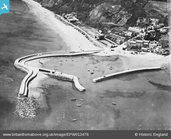
EPW013476 ENGLAND (1925). The Cobb and Monmouth Beach, Lyme Regis, 1925. This image has been produced from a copy-negative.
© Copyright OpenStreetMap contributors and licensed by the OpenStreetMap Foundation. 2024. Cartography is licensed as CC BY-SA.
Nearby Images (8)
EPW013476

EPW024178

EPW023895

EAW050065

EPW039714

EPW023894

EPW039716

EAW033661

Details
| Title | [EPW013476] The Cobb and Monmouth Beach, Lyme Regis, 1925. This image has been produced from a copy-negative. |
| Reference | EPW013476 |
| Date | June-1925 |
| Link | |
| Place name | LYME REGIS |
| Parish | LYME REGIS |
| District | |
| Country | ENGLAND |
| Easting / Northing | 333906, 91575 |
| Longitude / Latitude | -2.9363811423769, 50.719464916943 |
| National Grid Reference | SY339916 |
Pins
 Dylan Moore |
Monday 2nd of November 2015 11:36:35 PM | |
Dylan Moore |
Monday 2nd of November 2015 11:35:28 PM | |
Dylan Moore |
Monday 2nd of November 2015 11:34:55 PM | |
Dylan Moore |
Monday 2nd of November 2015 11:34:19 PM | |
 Alan McFaden |
Monday 17th of November 2014 07:26:03 PM | |
Dylan Moore |
Monday 17th of November 2014 10:41:44 AM |

User Comment Contributions
I am informed by Lyme Regis Museum that a sale of the cement works equipment took place in May 1925, and much of it was removed shortly afterwards. This fuzzy image is the only known (as yet) evidence of the location of a rotary kiln, virtually on the water's edge. Some images from this flight appear to be missing - could they be close-ups? Update: a postcard image from the Cobb also turned up - equally fuzzy. |
Dylan Moore |
Thursday 5th of November 2015 10:48:49 AM |
 Lyme Regis Harbour |
Alan McFaden |
Monday 17th of November 2014 07:25:21 PM |
 The Cobb Lyme Regis |
Alan McFaden |
Monday 17th of November 2014 07:24:39 PM |


