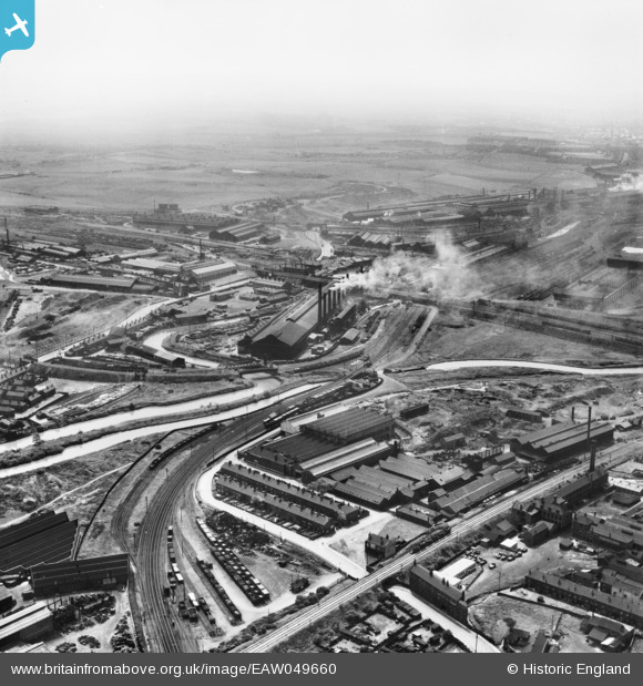
EAW049660 ENGLAND (1953). The industrial landscape of New York, Ickles and Templeborough, Rotherham, from the north-east, 1953
© Copyright OpenStreetMap contributors and licensed by the OpenStreetMap Foundation. 2024. Cartography is licensed as CC BY-SA.
Nearby Images (17)
Details
| Title | [EAW049660] The industrial landscape of New York, Ickles and Templeborough, Rotherham, from the north-east, 1953 |
| Reference | EAW049660 |
| Date | 24-May-1953 |
| Link | |
| Place name | ROTHERHAM |
| Parish | |
| District | |
| Country | ENGLAND |
| Easting / Northing | 442219, 392420 |
| Longitude / Latitude | -1.36455630492, 53.426621195252 |
| National Grid Reference | SK422924 |
Pins
Be the first to add a comment to this image!


![[EAW049660] The industrial landscape of New York, Ickles and Templeborough, Rotherham, from the north-east, 1953](http://britainfromabove.org.uk/sites/all/libraries/aerofilms-images/public/100x100/EAW/049/EAW049660.jpg)
![[EAW049661] The industrial landscape of New York, Ickles and Templeborough, Rotherham, from the north-east, 1953](http://britainfromabove.org.uk/sites/all/libraries/aerofilms-images/public/100x100/EAW/049/EAW049661.jpg)
![[EAW049658] The industrial landscape of New York, Ickles and Templeborough, Rotherham, from the north-east, 1953](http://britainfromabove.org.uk/sites/all/libraries/aerofilms-images/public/100x100/EAW/049/EAW049658.jpg)
![[EAW048632] The British Oxygen Co Ltd Oxygen Works on Armer Street, Masbrough, 1953. This image was marked by Aerofilms Ltd for photo editing.](http://britainfromabove.org.uk/sites/all/libraries/aerofilms-images/public/100x100/EAW/048/EAW048632.jpg)
![[EAW049657] The industrial landscape of New York, Ickles and Templeborough, Rotherham, from the north-east, 1953](http://britainfromabove.org.uk/sites/all/libraries/aerofilms-images/public/100x100/EAW/049/EAW049657.jpg)
![[EAW048649] The British Oxygen Co Ltd Oxygen Works on Armer Street, Masbrough, 1953. This image was marked by Aerofilms Ltd for photo editing.](http://britainfromabove.org.uk/sites/all/libraries/aerofilms-images/public/100x100/EAW/048/EAW048649.jpg)
![[EAW048629] The British Oxygen Co Ltd Oxygen Works on Armer Street and environs, Masbrough, 1953. This image was marked by Aerofilms Ltd for photo editing.](http://britainfromabove.org.uk/sites/all/libraries/aerofilms-images/public/100x100/EAW/048/EAW048629.jpg)
![[EAW049662] The industrial landscape of New York, Ickles and Templeborough, Rotherham, 1953](http://britainfromabove.org.uk/sites/all/libraries/aerofilms-images/public/100x100/EAW/049/EAW049662.jpg)
![[EAW048633] The British Oxygen Co Ltd Oxygen Works on Armer Street and environs, Masbrough, 1953. This image was marked by Aerofilms Ltd for photo editing.](http://britainfromabove.org.uk/sites/all/libraries/aerofilms-images/public/100x100/EAW/048/EAW048633.jpg)
![[EAW048631] Industrial area around Masborough South Junction, Masbrough, from the north-east, 1953](http://britainfromabove.org.uk/sites/all/libraries/aerofilms-images/public/100x100/EAW/048/EAW048631.jpg)
![[EAW048636] The British Oxygen Co Ltd Oxygen Works on Armer Street and environs, Rotherham, 1953. This image was marked by Aerofilms Ltd for photo editing.](http://britainfromabove.org.uk/sites/all/libraries/aerofilms-images/public/100x100/EAW/048/EAW048636.jpg)
![[EAW048634] The British Oxygen Co Ltd Oxygen Works on Armer Street and environs, Masbrough, 1953. This image was marked by Aerofilms Ltd for photo editing.](http://britainfromabove.org.uk/sites/all/libraries/aerofilms-images/public/100x100/EAW/048/EAW048634.jpg)
![[EAW048635] The British Oxygen Co Ltd Oxygen Works on Armer Street, Ickles Lock and environs, Masbrough, 1953. This image was marked by Aerofilms Ltd for photo editing.](http://britainfromabove.org.uk/sites/all/libraries/aerofilms-images/public/100x100/EAW/048/EAW048635.jpg)
![[EAW048637] The British Oxygen Co Ltd Oxygen Works on Armer Street, Ickles Lock and environs, Masbrough, 1953. This image was marked by Aerofilms Ltd for photo editing.](http://britainfromabove.org.uk/sites/all/libraries/aerofilms-images/public/100x100/EAW/048/EAW048637.jpg)
![[EAW048630] Industrial area around Masborough South Junction, Rotherham, from the north-east, 1953](http://britainfromabove.org.uk/sites/all/libraries/aerofilms-images/public/100x100/EAW/048/EAW048630.jpg)
![[EAW048638] The British Oxygen Co Ltd Oxygen Works on Armer Street, Phoenix Special Steel Works and environs, Rotherham, 1953. This image was marked by Aerofilms Ltd for photo editing.](http://britainfromabove.org.uk/sites/all/libraries/aerofilms-images/public/100x100/EAW/048/EAW048638.jpg)
![[EAW049659] The industrial landscape of New York, Ickles and Templeborough, Rotherham, 1953](http://britainfromabove.org.uk/sites/all/libraries/aerofilms-images/public/100x100/EAW/049/EAW049659.jpg)


