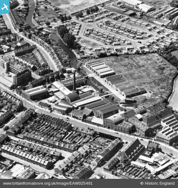
EAW025491 ENGLAND (1949). The Wandleside Cable Works and Garratt Lane, Wandsworth, 1949. This image has been produced from a print.
© Copyright OpenStreetMap contributors and licensed by the OpenStreetMap Foundation. 2024. Cartography is licensed as CC BY-SA.
Nearby Images (7)
Details
| Title | [EAW025491] The Wandleside Cable Works and Garratt Lane, Wandsworth, 1949. This image has been produced from a print. |
| Reference | EAW025491 |
| Date | 26-July-1949 |
| Link | |
| Place name | WANDSWORTH |
| Parish | |
| District | |
| Country | ENGLAND |
| Easting / Northing | 525786, 174023 |
| Longitude / Latitude | -0.18956539675126, 51.450712288035 |
| National Grid Reference | TQ258740 |
Pins
 brianbeckett |
Wednesday 1st of October 2014 08:03:29 PM |


![[EAW025491] The Wandleside Cable Works and Garratt Lane, Wandsworth, 1949. This image has been produced from a print.](http://britainfromabove.org.uk/sites/all/libraries/aerofilms-images/public/100x100/EAW/025/EAW025491.jpg)
![[EAW025493] The Wandleside Cable Works and Wandsworth Open Air Swimming Pool, Wandsworth, 1949. This image has been produced from a print.](http://britainfromabove.org.uk/sites/all/libraries/aerofilms-images/public/100x100/EAW/025/EAW025493.jpg)
![[EAW025492] The Wandleside Cable Works, Wandsworth, 1949. This image has been produced from a print.](http://britainfromabove.org.uk/sites/all/libraries/aerofilms-images/public/100x100/EAW/025/EAW025492.jpg)
![[EAW025489] Garratt Lane and the Wandleside Cable Works, Wandsworth, 1949. This image has been produced from a print.](http://britainfromabove.org.uk/sites/all/libraries/aerofilms-images/public/100x100/EAW/025/EAW025489.jpg)
![[EAW025488] Garratt Lane and the Wandleside Cable Works, Wandsworth, 1949. This image has been produced from a print.](http://britainfromabove.org.uk/sites/all/libraries/aerofilms-images/public/100x100/EAW/025/EAW025488.jpg)
![[EAW025494] The Wandleside Cable Works, Wandsworth, 1949. This image has been produced from a print.](http://britainfromabove.org.uk/sites/all/libraries/aerofilms-images/public/100x100/EAW/025/EAW025494.jpg)
![[EAW025490] The Wandleside Cable Works, Wandsworth, 1949. This image has been produced from a print.](http://britainfromabove.org.uk/sites/all/libraries/aerofilms-images/public/100x100/EAW/025/EAW025490.jpg)


