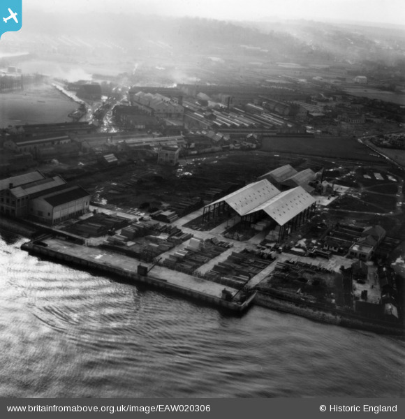
EAW020306 ENGLAND (1948). The W. R. Crow & Sons Ltd Timber Yard, Jenningtree Point, from the north-east, 1948. This image has been produced from a print.
© Copyright OpenStreetMap contributors and licensed by the OpenStreetMap Foundation. 2024. Cartography is licensed as CC BY-SA.
Nearby Images (28)
Details
| Title | [EAW020306] The W. R. Crow & Sons Ltd Timber Yard, Jenningtree Point, from the north-east, 1948. This image has been produced from a print. |
| Reference | EAW020306 |
| Date | 4-November-1948 |
| Link | |
| Place name | JENNINGTREE POINT |
| Parish | |
| District | |
| Country | ENGLAND |
| Easting / Northing | 550805, 179955 |
| Longitude / Latitude | 0.17280961875854, 51.497906846481 |
| National Grid Reference | TQ508800 |
Pins
Be the first to add a comment to this image!


![[EAW020306] The W. R. Crow & Sons Ltd Timber Yard, Jenningtree Point, from the north-east, 1948. This image has been produced from a print.](http://britainfromabove.org.uk/sites/all/libraries/aerofilms-images/public/100x100/EAW/020/EAW020306.jpg)
![[EAW020307] The W. R. Crow & Sons Ltd Timber Yard, Jenningtree Point, from the north-east, 1948. This image has been produced from a print.](http://britainfromabove.org.uk/sites/all/libraries/aerofilms-images/public/100x100/EAW/020/EAW020307.jpg)
![[EAW020317] The W. R. Crow & Sons Ltd Timber Yard and the River Thames, Jenningtree Point, 1948. This image has been produced from a damaged negative.](http://britainfromabove.org.uk/sites/all/libraries/aerofilms-images/public/100x100/EAW/020/EAW020317.jpg)
![[EAW020308A] The W. R. Crow & Sons Ltd Timber Yard, Jenningtree Point, 1948. This image was modified by the Aerofilms Ltd Artists' Department and has been produced from a copy-negative.](http://britainfromabove.org.uk/sites/all/libraries/aerofilms-images/public/100x100/EAW/020/EAW020308A.jpg)
![[EAW020316] The W. R. Crow & Sons Ltd Timber Yard, Jenningtree Point, 1948. This image has been produced from a damaged negative.](http://britainfromabove.org.uk/sites/all/libraries/aerofilms-images/public/100x100/EAW/020/EAW020316.jpg)
![[EAW020308] The W. R. Crow & Sons Ltd Timber Yard, Jenningtree Point, 1948. This image has been produced from a print.](http://britainfromabove.org.uk/sites/all/libraries/aerofilms-images/public/100x100/EAW/020/EAW020308.jpg)
![[EAW020311] The W. R. Crow & Sons Ltd Timber Yard and environs, Jenningtree Point, 1948. This image has been produced from a print.](http://britainfromabove.org.uk/sites/all/libraries/aerofilms-images/public/100x100/EAW/020/EAW020311.jpg)
![[EAW020313] The W. R. Crow & Sons Ltd Timber Yard, the River Thames and environs, Jenningtree Point, 1948. This image has been produced from a print marked by Aerofilms Ltd for photo editing.](http://britainfromabove.org.uk/sites/all/libraries/aerofilms-images/public/100x100/EAW/020/EAW020313.jpg)
![[EAW020314] The W. R. Crow & Sons Ltd Timber Yard, the River Thames and environs, Jenningtree Point, 1948. This image has been produced from a print marked by Aerofilms Ltd for photo editing.](http://britainfromabove.org.uk/sites/all/libraries/aerofilms-images/public/100x100/EAW/020/EAW020314.jpg)
![[EAW020315] The W. R. Crow & Sons Ltd Timber Yard and environs, Jenningtree Point, 1948. This image has been produced from a print.](http://britainfromabove.org.uk/sites/all/libraries/aerofilms-images/public/100x100/EAW/020/EAW020315.jpg)
![[EPW037910A] Callenders Cable Works and environs, Erith, from the north-east, 1932](http://britainfromabove.org.uk/sites/all/libraries/aerofilms-images/public/100x100/EPW/037/EPW037910A.jpg)
![[EAW037702] Mulberry Wharf near Jenningtree Point, Erith, 1951. This image has been produced from a print marked by Aerofilms Ltd for photo editing.](http://britainfromabove.org.uk/sites/all/libraries/aerofilms-images/public/100x100/EAW/037/EAW037702.jpg)
![[EAW037704] Mulberry Wharf near Jenningtree Point, Erith, 1951. This image has been produced from a print marked by Aerofilms Ltd for photo editing.](http://britainfromabove.org.uk/sites/all/libraries/aerofilms-images/public/100x100/EAW/037/EAW037704.jpg)
![[EAW020310] The W. R. Crow & Sons Ltd Timber Yard and environs, Jenningtree Point, 1948. This image has been produced from a print marked by Aerofilms Ltd for photo editing.](http://britainfromabove.org.uk/sites/all/libraries/aerofilms-images/public/100x100/EAW/020/EAW020310.jpg)
![[EAW037705] Mulberry Wharf near Jenningtree Point, Erith, 1951. This image has been produced from a print marked by Aerofilms Ltd for photo editing.](http://britainfromabove.org.uk/sites/all/libraries/aerofilms-images/public/100x100/EAW/037/EAW037705.jpg)
![[EAW020309] The W. R. Crow & Sons Ltd Timber Yard and environs, Jenningtree Point, 1948. This image has been produced from a print marked by Aerofilms Ltd for photo editing.](http://britainfromabove.org.uk/sites/all/libraries/aerofilms-images/public/100x100/EAW/020/EAW020309.jpg)
![[EAW037707] Mulberry Wharf near Jenningtree Point and environs, Erith, 1951. This image has been produced from a print marked by Aerofilms Ltd for photo editing.](http://britainfromabove.org.uk/sites/all/libraries/aerofilms-images/public/100x100/EAW/037/EAW037707.jpg)
![[EPW037905] Callenders Cable Works, Erith, 1932](http://britainfromabove.org.uk/sites/all/libraries/aerofilms-images/public/100x100/EPW/037/EPW037905.jpg)
![[EPW037315] Callender's Cable and Construction Company Ltd Works, Erith, 1932](http://britainfromabove.org.uk/sites/all/libraries/aerofilms-images/public/100x100/EPW/037/EPW037315.jpg)
![[EAW020312] The W. R. Crow & Sons Ltd Timber Yard, the River Thames and environs, Jenningtree Point, 1948. This image has been produced from a print marked by Aerofilms Ltd for photo editing.](http://britainfromabove.org.uk/sites/all/libraries/aerofilms-images/public/100x100/EAW/020/EAW020312.jpg)
![[EAW037703] Mulberry Wharf near Jenningtree Point, Erith, 1951. This image has been produced from a print marked by Aerofilms Ltd for photo editing.](http://britainfromabove.org.uk/sites/all/libraries/aerofilms-images/public/100x100/EAW/037/EAW037703.jpg)
![[EAW037708] Mulberry Wharf near Jenningtree Point, Erith, 1951. This image has been produced from a print marked by Aerofilms Ltd for photo editing.](http://britainfromabove.org.uk/sites/all/libraries/aerofilms-images/public/100x100/EAW/037/EAW037708.jpg)
![[EPW037910] Callenders Cable Works, Erith, 1932](http://britainfromabove.org.uk/sites/all/libraries/aerofilms-images/public/100x100/EPW/037/EPW037910.jpg)
![[EAW020318] The W. R. Crow & Sons Ltd Timber Yard, the River Thames and environs, Jenningtree Point, 1948. This image was marked by Aerofilms Ltd for photo editing.](http://britainfromabove.org.uk/sites/all/libraries/aerofilms-images/public/100x100/EAW/020/EAW020318.jpg)
![[EAW037701] Mulberry Wharf near Jenningtree Point, Erith, from the north-east, 1951. This image has been produced from a print marked by Aerofilms Ltd for photo editing.](http://britainfromabove.org.uk/sites/all/libraries/aerofilms-images/public/100x100/EAW/037/EAW037701.jpg)
![[EAW048354] Flooding at the British Insulated Callender's Cables Ltd Erith Works, Erith, 1953](http://britainfromabove.org.uk/sites/all/libraries/aerofilms-images/public/100x100/EAW/048/EAW048354.jpg)
![[EPW037909] Callenders Cable Works and environs, Erith, 1932](http://britainfromabove.org.uk/sites/all/libraries/aerofilms-images/public/100x100/EPW/037/EPW037909.jpg)
![[EPW037904] Callenders Cable Works, Erith, 1932](http://britainfromabove.org.uk/sites/all/libraries/aerofilms-images/public/100x100/EPW/037/EPW037904.jpg)


