
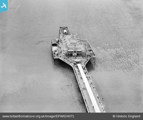
EPW024071 ENGLAND (1928). The Grand Pier, Weston-super-Mare, 1928
© Hawlfraint cyfranwyr OpenStreetMap a thrwyddedwyd gan yr OpenStreetMap Foundation. 2024. Trwyddedir y gartograffeg fel CC BY-SA.
Delweddau cyfagos (18)
EPW024071

EPW048452

EPW023967

EPW033286

EPW023966

EPW048451

EPW048453

EAW016134

EAW016133

EPW039934

EPW001039

EPW024075

EAW025155

EPW051716

EPW048443

EAW015058

EPW023969

EPW024072

Manylion
| Pennawd | [EPW024071] The Grand Pier, Weston-super-Mare, 1928 |
| Cyfeirnod | EPW024071 |
| Dyddiad | September-1928 |
| Dolen | |
| Enw lle | WESTON-SUPER-MARE |
| Plwyf | WESTON-SUPER-MARE |
| Ardal | |
| Gwlad | ENGLAND |
| Dwyreiniad / Gogleddiad | 331436, 161424 |
| Hydred / Lledred | -2.9845902639701, 51.347254889455 |
| Cyfeirnod Grid Cenedlaethol | ST314614 |
Pinnau
Byddwch y cyntaf i ychwanegu sylw at y ddelwedd hon!
Cyfraniadau Grŵp
 The Grand Pier Weston-super-Mare |
 Alan McFaden |
Friday 5th of December 2014 01:22:46 PM |
The pier first opened on 11 June 1904. An extension, built in 1907, was later demolished. The pier's theatre was destroyed by fire in 1930. A further major fire in 2008 resulted in major rebuilding of the pavilion and the pier re-opened on 23 October 2010 |
 MB |
Monday 10th of September 2012 10:32:23 PM |


