
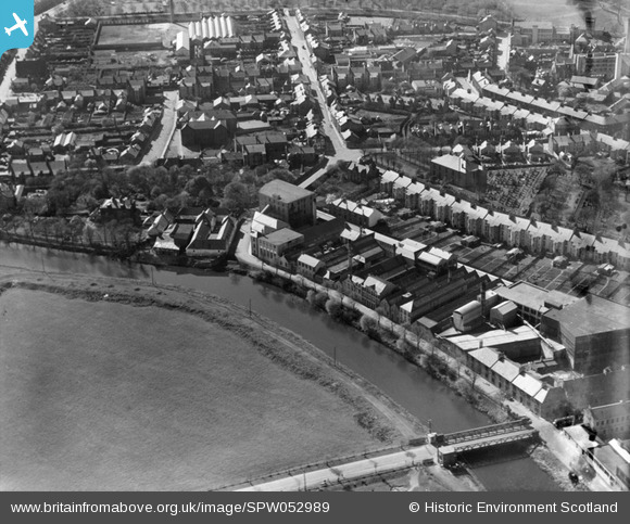
spw052989 SCOTLAND (1937). Kilmarnock, general view, showing Fleming's Lace Mill, Lawson Street and East Netherton Street. An oblique aerial photograph taken facing west.
© Copyright OpenStreetMap contributors and licensed by the OpenStreetMap Foundation. 2025. Cartography is licensed as CC BY-SA.
Nearby Images (3)
SPW019527

SPW052989

SPW052990

Details
| Title | [SPW052989] Kilmarnock, general view, showing Fleming's Lace Mill, Lawson Street and East Netherton Street. An oblique aerial photograph taken facing west. |
| Reference | SPW052989 |
| Date | 1937 |
| Link | Canmore Collection item 1258103 |
| Place name | |
| Parish | KILMARNOCK |
| District | KILMARNOCK AND LOUDOUN |
| Country | SCOTLAND |
| Easting / Northing | 243046, 637166 |
| Longitude / Latitude | -4.4916204390806, 55.602757984495 |
| National Grid Reference | NS430372 |
Pins
.JPG?itok=rAaEpDPq) |
 Cameron1869 |
Tuesday 29th of December 2015 04:02:44 PM |
olddobson |
Wednesday 11th of September 2013 09:17:00 AM | |
olddobson |
Wednesday 11th of September 2013 09:11:57 AM | |
 |
Cameron1869 |
Saturday 30th of June 2012 08:57:21 AM |
User Comment Contributions
I stayed in the defiance building that sat at the corner of Lawson st across from the lounge door of the Bellfield Tavern where the new houses are now.I moved at the same time as I think this is when all the old streets were demolished. I was only 5 at the time so don't remember to much.It is great to see the streets but I can't get any pictures of the defiance building but can just see a small part of the back of it in one of the pictures,next to the B.M.K. |
charlie1963 |
Thursday 24th of January 2013 07:30:21 PM |