
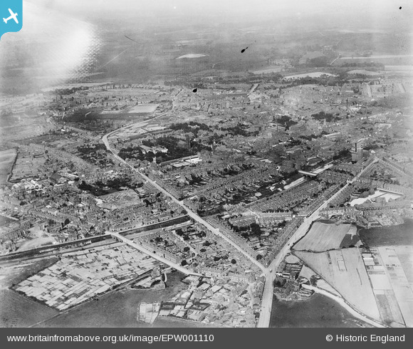
epw001110 ENGLAND (1920). General view of central West Bromwich, West Bromwich, from the south-west, 1920
© Copyright OpenStreetMap contributors and licensed by the OpenStreetMap Foundation. 2025. Cartography is licensed as CC BY-SA.
Nearby Images (2)
EPW001110

EPW001112

Details
| Title | [EPW001110] General view of central West Bromwich, West Bromwich, from the south-west, 1920 |
| Reference | EPW001110 |
| Date | May-1920 |
| Link | |
| Place name | WEST BROMWICH |
| Parish | |
| District | |
| Country | ENGLAND |
| Easting / Northing | 399781, 291329 |
| Longitude / Latitude | -2.0032278728182, 52.519477251932 |
| National Grid Reference | SO998913 |
Pins

DaveT |
Sunday 20th of April 2014 10:17:53 AM | |
|
DaveT |
Sunday 20th of April 2014 09:58:15 AM | |
|
DaveT |
Sunday 20th of April 2014 09:44:49 AM | |
|
DaveT |
Sunday 20th of April 2014 09:41:39 AM | |
|
DaveT |
Saturday 19th of April 2014 08:58:55 PM | |
|
DaveT |
Saturday 19th of April 2014 06:25:43 PM | |
|
DaveT |
Saturday 19th of April 2014 06:22:57 PM | |
|
DaveT |
Saturday 19th of April 2014 06:16:28 PM | |
|
DaveT |
Saturday 19th of April 2014 06:01:14 PM | |
|
DaveT |
Saturday 19th of April 2014 05:53:56 PM | |
|
DaveT |
Monday 3rd of February 2014 01:52:38 PM | |
|
Stevie Flower |
Wednesday 27th of June 2012 10:03:35 PM | |
|
Stevie Flower |
Wednesday 27th of June 2012 10:01:57 PM |
User Comment Contributions
I was a member of the choir at this church during the late 1930's. I believe it was later burnt down by an arsonist. |
Hotspur |
Saturday 25th of August 2012 08:39:46 PM |