
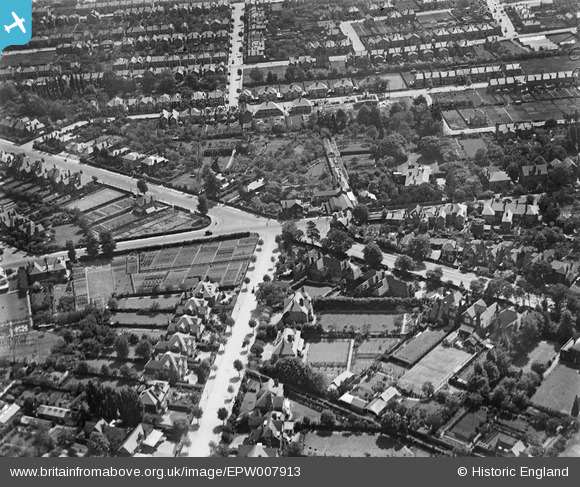
EPW007913 ENGLAND (1922). The junction of Ditton Road and Upper Brighton Road, Southborough, 1922
© Copyright OpenStreetMap contributors and licensed by the OpenStreetMap Foundation. 2025. Cartography is licensed as CC BY-SA.
Nearby Images (3)
EPW007913

EPW007914

EPW008690

Details
| Title | [EPW007913] The junction of Ditton Road and Upper Brighton Road, Southborough, 1922 |
| Reference | EPW007913 |
| Date | May-1922 |
| Link | |
| Place name | SOUTHBOROUGH |
| Parish | |
| District | |
| Country | ENGLAND |
| Easting / Northing | 518355, 166244 |
| Longitude / Latitude | -0.29906505536064, 51.382391851789 |
| National Grid Reference | TQ184662 |
Pins

Pip |
Friday 7th of February 2014 01:27:01 PM | |
|
Pip |
Thursday 2nd of January 2014 04:34:18 PM | |
|
Pip |
Thursday 2nd of January 2014 04:32:33 PM | |
|
Pip |
Thursday 2nd of January 2014 04:32:12 PM | |
|
Pip |
Thursday 2nd of January 2014 04:31:45 PM | |
|
Pip |
Thursday 2nd of January 2014 04:30:08 PM | |
|
Pip |
Thursday 2nd of January 2014 04:27:25 PM | |

Dylan Moore |
Saturday 4th of May 2013 03:52:28 PM | |
|
Dylan Moore |
Saturday 4th of May 2013 03:51:54 PM | |
|
Dylan Moore |
Saturday 4th of May 2013 03:51:08 PM | |
|
Dylan Moore |
Saturday 4th of May 2013 03:50:37 PM | |
|
Dylan Moore |
Saturday 4th of May 2013 03:50:08 PM |
User Comment Contributions
Hi Dylan, Thanks for locating this one. We'll update the catalogue, and post the ammended record here in due course. Yours, Katy Britain from Above Cataloguing Team Leader |
Katy Whitaker |
Monday 1st of July 2013 12:45:58 PM |