
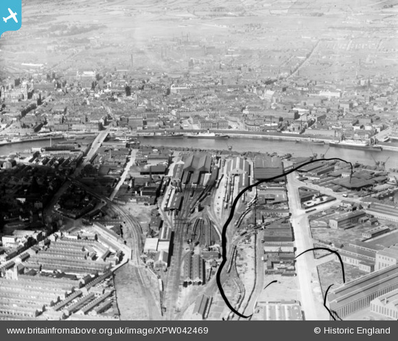
XPW042469 NORTHERN IRELAND (1933). General View, Belfast, Belfast, Northern Ireland, 1933. Oblique aerial photograph taken facing West. This image has been produced from a damaged negative.
© Copyright OpenStreetMap contributors and licensed by the OpenStreetMap Foundation. 2026. Cartography is licensed as CC BY-SA.
Nearby Images (5)
XPW042469

XAW032811

XAW032813

XAW032816

XPW033856

Details
| Title | [XPW042469] General View, Belfast, Belfast, Northern Ireland, 1933. Oblique aerial photograph taken facing West. This image has been produced from a damaged negative. |
| Reference | XPW042469 |
| Date | 1933 |
| Link | |
| Place name | BELFAST |
| Parish | NORTHERN IRELAND |
| District | |
| Country | NORTHERN IRELAND |
| Easting / Northing | 147642, 529930 |
| Longitude / Latitude | -5.908773, 54.601332 |
| National Grid Reference |
Pins

john little |
Tuesday 4th of November 2014 12:01:48 AM | |
|
john little |
Monday 3rd of November 2014 11:59:52 PM | |
|
john little |
Monday 3rd of November 2014 11:58:41 PM | |
|
john little |
Monday 3rd of November 2014 11:57:46 PM | |
|
john little |
Monday 3rd of November 2014 11:56:18 PM | |
|
john little |
Monday 3rd of November 2014 11:55:18 PM | |
|
john little |
Monday 3rd of November 2014 11:54:23 PM | |
|
john little |
Monday 3rd of November 2014 11:53:47 PM | |
|
john little |
Monday 3rd of November 2014 11:53:21 PM | |
|
john little |
Monday 3rd of November 2014 11:52:57 PM | |
|
john little |
Monday 3rd of November 2014 11:52:16 PM |
User Comment Contributions
The terminus of the Belfast & County Down Railway was located on the eastern bank of the river Lagan at Queen's Quay, Belfast. |
john little |
Tuesday 4th of November 2014 12:04:35 AM |