
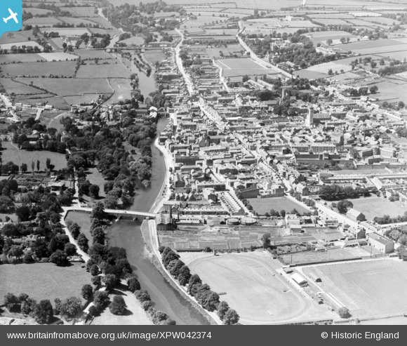
XPW042374 IRELAND (1933). General View, Clonnel, Tipperary, Ireland, 1933. Oblique aerial photograph taken facing West.
© Copyright OpenStreetMap contributors and licensed by the OpenStreetMap Foundation. 2026. Cartography is licensed as CC BY-SA.
Nearby Images (2)
XPW042374

XPW042371

Details
| Title | [XPW042374] General View, Clonnel, Tipperary, Ireland, 1933. Oblique aerial photograph taken facing West. |
| Reference | XPW042374 |
| Date | 1933 |
| Link | |
| Place name | CLONNEL |
| Parish | IRELAND |
| District | |
| Country | IRELAND |
| Easting / Northing | 12205, 288105 |
| Longitude / Latitude | -7.697398, 52.353381 |
| National Grid Reference |
Pins

John |
Saturday 28th of February 2026 03:21:05 PM | |
|
John |
Saturday 28th of February 2026 03:20:46 PM | |
|
John |
Saturday 28th of February 2026 03:20:06 PM | |
|
John |
Saturday 28th of February 2026 03:19:41 PM | |
|
John |
Saturday 28th of February 2026 03:19:15 PM | |
|
John |
Saturday 28th of February 2026 03:18:37 PM | |
|
John |
Saturday 28th of February 2026 03:18:26 PM | |
|
John |
Saturday 28th of February 2026 03:18:00 PM | |
|
John |
Saturday 28th of February 2026 03:17:19 PM | |
|
John |
Saturday 28th of February 2026 03:17:06 PM | |
|
John |
Saturday 28th of February 2026 03:16:47 PM | |
|
John |
Saturday 28th of February 2026 03:16:28 PM | |
|
John |
Saturday 28th of February 2026 12:13:34 PM | |
|
Raggaroo |
Friday 1st of November 2019 03:36:12 PM | |
|
Raggaroo |
Tuesday 17th of September 2019 02:28:46 PM | |
|
Raggaroo |
Tuesday 17th of September 2019 02:26:16 PM | |

John Swain |
Sunday 12th of October 2014 02:52:17 PM | |
|
John Swain |
Sunday 12th of October 2014 02:50:37 PM | |
|
John Swain |
Sunday 12th of October 2014 02:48:40 PM | |
|
John Swain |
Sunday 12th of October 2014 02:47:21 PM | |
|
John Swain |
Sunday 12th of October 2014 02:44:54 PM | |
|
John Swain |
Sunday 12th of October 2014 02:38:49 PM | |
|
John Swain |
Sunday 12th of October 2014 02:35:45 PM | |
|
John Swain |
Sunday 12th of October 2014 02:35:04 PM | |
|
John Swain |
Sunday 12th of October 2014 02:34:13 PM | |
|
John Swain |
Sunday 12th of October 2014 02:31:44 PM | |
|
John Swain |
Sunday 12th of October 2014 02:31:05 PM | |
|
John Swain |
Sunday 12th of October 2014 02:30:19 PM | |
|
John Swain |
Sunday 12th of October 2014 02:29:01 PM | |
|
John Swain |
Sunday 12th of October 2014 02:27:01 PM | |
|
John Swain |
Sunday 12th of October 2014 02:24:53 PM | |
These barracks were named after local poet, writer and revolutionary, Charles J. Kickham (1826-82), and a statue is located in nearby Tipperary Town to commemorate his achievements. |
John Swain |
Monday 13th of October 2014 11:03:15 AM |
|
John Swain |
Sunday 12th of October 2014 02:23:12 PM | |
|
John Swain |
Sunday 12th of October 2014 02:22:35 PM | |
|
John Swain |
Sunday 12th of October 2014 02:19:50 PM | |
|
John Swain |
Sunday 12th of October 2014 02:19:06 PM | |
|
John Swain |
Sunday 12th of October 2014 02:18:33 PM | |
|
John Swain |
Sunday 12th of October 2014 02:16:45 PM | |
|
John Swain |
Sunday 12th of October 2014 02:16:07 PM | |
|
John Swain |
Sunday 12th of October 2014 02:14:07 PM | |
|
John Swain |
Sunday 12th of October 2014 02:13:13 PM |
User Comment Contributions
As befits a name Cluain Meala, meaning "meadow of honey", Clonmel has thrived on the waters and productive soils of the Suir Valley and has associated industries such as meat, cider, mineral waters and soft drinks, woollens, in addition to fellmongery, light engineering (car components and prams) and footwear. It is the largest town in County Tipperary and has been the foremost urban centre in the region for centuries. In 1821, the population reached a peak of 15,590, which has been rivalled only in very recent times (15,793 in 2011). When this image was taken in 1933, the town contained fewer than 9,500, which is hardly surprising bearing in mind the devastating drop in the county's population from 435,000 in 1841 to 138,000 in 1936. There has been a slight recovery in post-Emergency times to 149,000 in 2006. An important stone-built railway station was located on the north side of the town (not in picture) in 1852, with links to both Waterford and Limerick. East of the station, there was a branch line to Thurles, from 1879 until 1967, which provided the essential contact with Dublin. A rail siding from Clonmel Junction served Powerstown Park until 1971, close to the famous racecourse of the same name, which was founded in 1813 and refurbished in 1998. Clonmel's pre-eminence as a river port in the 18th and 19th centuries faded with the development of the railway from the 1850s onwards. Clonmel has been capital of the county since 1328 and has served as the administrative centre for the South Riding of Tipperary from 1838. This writer has known the town for 50 years and it remains one of his favourite localities within the Republic! |
John Swain |
Sunday 12th of October 2014 03:29:29 PM |