
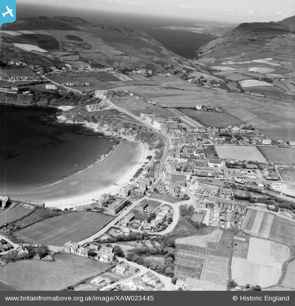
XAW023445 ISLE OF MAN (1949). General View, Port of Erin, Isle of Man, Isle of Man, 1949. Oblique aerial photograph taken facing North.
© Copyright OpenStreetMap contributors and licensed by the OpenStreetMap Foundation. 2026. Cartography is licensed as CC BY-SA.
Nearby Images (2)
XAW023445

XAW023443

Details
| Title | [XAW023445] General View, Port of Erin, Isle of Man, Isle of Man, 1949. Oblique aerial photograph taken facing North. |
| Reference | XAW023445 |
| Date | 26-May-1949 |
| Link | |
| Place name | PORT OF ERIN |
| Parish | ISLE OF MAN |
| District | |
| Country | ISLE OF MAN |
| Easting / Northing | 219607, 469343 |
| Longitude / Latitude | -4.759577, 54.088301 |
| National Grid Reference |
Pins

MB |
Saturday 23rd of January 2021 08:21:01 PM | |
|
tangram |
Tuesday 20th of August 2019 08:54:24 PM | |
|
tangram |
Thursday 19th of April 2018 07:21:36 PM | |

John Swain |
Saturday 18th of October 2014 02:51:54 PM | |
|
John Swain |
Saturday 18th of October 2014 02:51:22 PM | |
|
John Swain |
Saturday 18th of October 2014 02:50:40 PM | |
|
John Swain |
Saturday 18th of October 2014 02:50:06 PM | |
|
John Swain |
Saturday 18th of October 2014 02:49:08 PM | |
|
John Swain |
Saturday 18th of October 2014 02:48:26 PM | |
|
John Swain |
Saturday 18th of October 2014 02:47:48 PM | |
|
John Swain |
Saturday 18th of October 2014 02:47:09 PM | |
|
John Swain |
Saturday 18th of October 2014 02:45:19 PM | |
|
John Swain |
Saturday 18th of October 2014 02:43:37 PM | |
|
John Swain |
Saturday 18th of October 2014 02:43:07 PM | |
|
John Swain |
Saturday 18th of October 2014 02:42:12 PM | |
|
John Swain |
Saturday 18th of October 2014 02:39:42 PM | |
|
John Swain |
Saturday 18th of October 2014 02:38:52 PM | |
|
John Swain |
Saturday 18th of October 2014 02:38:11 PM | |
|
John Swain |
Saturday 18th of October 2014 02:37:37 PM | |
|
John Swain |
Saturday 18th of October 2014 02:36:45 PM | |
|
John Swain |
Saturday 18th of October 2014 02:36:18 PM |
User Comment Contributions
In the 1930s, Port Erin ("Ireland's Port")was described in Bartholomew's Gazetteer of the British Isles as being a coastal village, lifeboat station and watering place, with a railway station, on Port Erin Bay, 15 and a half miles from Douglas. In earler days, Port Erin was a favoured spot for smuggling, but this was replaced by its 19th century popularity as the playground for the Lancashire mill owners and their employees. Port Erin remains a summer seaside resort of some significance, along with a flourishing Arts Centre and a Marine Biological Station established at the seaward end of the bay. |
John Swain |
Saturday 18th of October 2014 03:01:51 PM |