
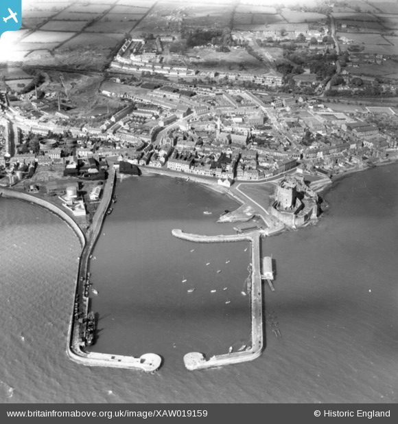
XAW019159 NORTHERN IRELAND (1948). Carrickfergus Castle, Carrickfergus, Carrickfergus, Northern Ireland, 1948. Oblique aerial photograph taken facing North.
© Copyright OpenStreetMap contributors and licensed by the OpenStreetMap Foundation. 2026. Cartography is licensed as CC BY-SA.
Nearby Images (7)
XAW019159

XPW015529

XPW015530

XPW028714

XPW028711

XPW028709

XPW015331

Details
| Title | [XAW019159] Carrickfergus Castle, Carrickfergus, Carrickfergus, Northern Ireland, 1948. Oblique aerial photograph taken facing North. |
| Reference | XAW019159 |
| Date | 25-September-1948 |
| Link | |
| Place name | CARRICKFERGUS |
| Parish | NORTHERN IRELAND |
| District | |
| Country | NORTHERN IRELAND |
| Easting / Northing | 154861, 542018 |
| Longitude / Latitude | -5.807427, 54.713274 |
| National Grid Reference |
Pins

manalive45 |
Tuesday 1st of December 2015 04:41:08 PM | |
|
manalive45 |
Tuesday 1st of December 2015 04:39:16 PM | |
|
ronnie |
Thursday 19th of March 2015 08:55:23 PM | |
|
ronnie |
Monday 16th of March 2015 04:14:41 PM | |
|
ronnie |
Monday 16th of March 2015 04:10:52 PM | |
|
ronnie |
Monday 16th of March 2015 04:08:07 PM | |
|
ronnie |
Monday 16th of March 2015 04:06:29 PM | |
|
ronnie |
Monday 16th of March 2015 04:00:52 PM | |
|
ronnie |
Monday 16th of March 2015 03:56:02 PM | |
|
ronnie |
Monday 16th of March 2015 02:01:34 PM | |
|
ronnie |
Monday 16th of March 2015 01:26:03 PM | |
|
ronnie |
Monday 16th of March 2015 01:24:45 PM | |
|
ronnie |
Monday 16th of March 2015 01:21:54 PM | |
|
ronnie |
Monday 16th of March 2015 12:11:30 PM | |
|
ronnie |
Monday 16th of March 2015 11:53:15 AM | |
(Louis MCneice.In spite of himself and his occasional disparaging remarks (mostly while a student) about his home town, there is a slightly begrudging recognition of the more romantic aspects of the area around the town, not least its place-names. Carrickfergus, he says, ‘was a name to be proud of .. but I disliked its abbreviation Carrick which in the local voice sounded like a slap in the face’.. Within our parish, radiating from our house, were a number of attractive names’. He itemises ‘the BUSKY BURN the Mile Bush, the Red Brae (there was nothing red about it but the red seemed to suit its steepness … right along the Sullatober Road, a musical purplish name’. |
ronnie |
Monday 16th of March 2015 01:53:35 PM |
|
ronnie |
Monday 16th of March 2015 11:46:45 AM | |
|
ronnie |
Monday 16th of March 2015 11:42:24 AM | |
|
ronnie |
Monday 16th of March 2015 11:39:49 AM | |
|
ronnie |
Monday 16th of March 2015 11:33:56 AM | |
|
ronnie |
Monday 16th of March 2015 11:33:51 AM | |
|
ronnie |
Monday 16th of March 2015 12:52:24 AM | |
|
ronnie |
Monday 16th of March 2015 12:49:51 AM | |
|
ronnie |
Monday 16th of March 2015 12:46:17 AM | |
Used as a community hall unil the council erected a purpose built hall on the site. |
ronnie |
Monday 16th of March 2015 01:41:13 PM |
|
ronnie |
Monday 16th of March 2015 12:46:16 AM | |
This was used as a community centre until a purpose built hall was erected on the site. |
ronnie |
Monday 16th of March 2015 01:37:42 PM |
|
ronnie |
Monday 16th of March 2015 12:41:46 AM | |
|
ronnie |
Monday 16th of March 2015 12:35:33 AM | |
|
ronnie |
Monday 16th of March 2015 12:30:07 AM | |
|
ronnie |
Monday 16th of March 2015 12:27:46 AM | |
|
Valerie |
Tuesday 14th of October 2014 12:26:29 AM |
User Comment Contributions

1948 |
Valerie |
Monday 13th of October 2014 11:02:56 PM |