
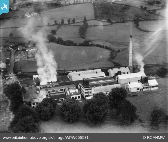
WPW055531 WALES (1937). View of Johnstown Milk Factory, oblique aerial view. 5"x4" black and white glass plate negative.
© Copyright OpenStreetMap contributors and licensed by the OpenStreetMap Foundation. 2026. Cartography is licensed as CC BY-SA.
Nearby Images (6)
WPW055528

WPW055529

WPW055530

WPW055531

WPW055532

WPW055533

Details
| Title | [WPW055531] View of Johnstown Milk Factory, oblique aerial view. 5"x4" black and white glass plate negative. |
| Reference | WPW055531 |
| Date | 22-September-1937 |
| Link | Coflein Archive Item 6370185 |
| Place name | |
| Parish | |
| District | |
| Country | WALES |
| Easting / Northing | 240105, 219304 |
| Longitude / Latitude | -4.3216833412394, 51.848955834114 |
| National Grid Reference | SN401193 |
Pins
User Comment Contributions
Well done JohnB. A view looking north at Llanstephan Crossing. The Picton Memorial is just in view. |

Class31 |
Wednesday 11th of July 2012 10:19:49 AM |
This is not Newcastle Emlyn. It's the former Cow & Gate, latterly Dairy Crest, creamery, adjacent to the South Wales main railway line in Johnstown, Carmarthen. All the views of this location I have found so far are: *WPW055528 *WPW055529 *WPW055530 *WPW055531 *WPW055532 *WPW055533 The site today can be seen on Google Maps - http://goo.gl/maps/bNJz This is a link to my source for this information - http://peoplescollectionwales.co.uk/Item/29184 |

JohnB |
Thursday 28th of June 2012 02:38:05 PM |