
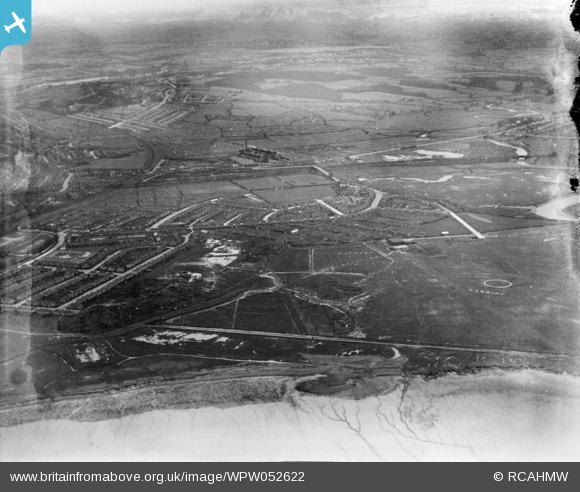
WPW052622 WALES (1937). Distant view of new housing at Newport, oblique aerial view. 5"x4" black and white glass plate negative.
© Copyright OpenStreetMap contributors and licensed by the OpenStreetMap Foundation. 2026. Cartography is licensed as CC BY-SA.
Nearby Images (48)
WPW000947

WPW000949

WPW000951

WPW000952

WPW000953

WPW000954

WPW022280

WPW022281

WPW022284

WPW022285

WPW022286

WPW029303

WPW029304

WPW029305

WPW029306

WPW029307

WPW029309

WPW029313

WPW032457

WPW032458

WPW032459

WPW032460

WPW032461

WPW032462

WPW032463

WPW052620

WPW052621

WPW052622

WPW052626

WPW052629

WPW052632

WPW052634

WPW052639

WPW052641

WPW052643

WPW052644

WPW052645

WPW052646

WPW052648

WPW052649

WPW052650

WPW052652

WPW052653

WPW052654

WPW052655

WPW052656

WPW052657

WPW052658

Details
| Title | [WPW052622] Distant view of new housing at Newport, oblique aerial view. 5"x4" black and white glass plate negative. |
| Reference | WPW052622 |
| Date | 1937 |
| Link | Coflein Archive Item 6370045 |
| Place name | |
| Parish | |
| District | |
| Country | WALES |
| Easting / Northing | 331010, 188330 |
| Longitude / Latitude | -2.9959602652742, 51.589120636107 |
| National Grid Reference | ST310883 |
Pins

Class31 |
Tuesday 4th of December 2012 08:06:34 AM | |
|
Class31 |
Tuesday 4th of December 2012 07:31:56 AM | |
This is the site of Cardiff Municipal Airport. |
Class31 |
Tuesday 4th of December 2012 07:37:52 AM |
|
Class31 |
Tuesday 4th of December 2012 07:31:25 AM | |
|
Class31 |
Tuesday 4th of December 2012 07:17:47 AM | |
|
Class31 |
Tuesday 4th of December 2012 07:17:13 AM | |
|
Class31 |
Tuesday 4th of December 2012 07:14:55 AM | |
|
Class31 |
Tuesday 4th of December 2012 07:13:01 AM | |
|
Class31 |
Tuesday 4th of December 2012 07:12:12 AM | |
|
Class31 |
Tuesday 4th of December 2012 07:10:31 AM | |
|
Class31 |
Tuesday 4th of December 2012 07:10:10 AM | |
|
Class31 |
Monday 3rd of December 2012 11:35:26 PM | |
|
Class31 |
Monday 3rd of December 2012 11:32:56 PM | |
|
Class31 |
Monday 3rd of December 2012 11:28:07 PM |
User Comment Contributions
Hi Class 31, This is indeed an image of Tremorfa, Cardiff. We will update the catalogue in due course. Thanks, Hefin |
Hefin Meara |
Thursday 11th of April 2013 04:14:00 PM |
All the evidence is that this is Tremorfa, Cardiff looking north with the former Cardiff Municipal Airport in the foreground and the Rhymney River on the right. The GWR South Wales Main Line runs across the shot in the middle distance with Roath Power Station in centre shot. This is a confirmed location from the evidence. The official location needs to be changed. |
Class31 |
Tuesday 4th of December 2012 08:00:51 AM |
If Newport road, Cardiff it would tally with the original location of Cardiff airport, hence the 'Cardiff' sign in a field |

ChrisBartley |
Monday 3rd of December 2012 09:34:30 PM |
Isn't this photograph of Newport Road, Cardiff? The old trolleybus power station just behind the bridge over the GWR main line with Tremorfa housing this side of the tracks? |
Cronin |
Sunday 5th of August 2012 12:34:57 PM |
This doesn't look like Newport. Cardiff maybe? Clue is the word 'Cardiff' marked in field on right with a circle. Any ideas what this is? A marker for aircraft? |
Ray |
Tuesday 26th of June 2012 06:53:22 PM |