
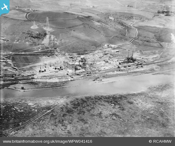
WPW041416 WALES (1933). View of construction of Oil Refinery, Llandarcy, oblique aerial view. 5"x4" black and white glass plate negative.
© Copyright OpenStreetMap contributors and licensed by the OpenStreetMap Foundation. 2026. Cartography is licensed as CC BY-SA.
Nearby Images (48)
WAW005772

WAW005773

WAW005774

WAW005776

WAW005777

WAW005778

WAW005779

WAW005780

WAW005781

WAW006989

WAW007000

WAW007001

WAW039160

WAW039161

WAW039162

WAW039163

WAW039164

WAW039165

WAW039166

WAW039167

WAW039168

WAW039169

WAW039170

WAW039171

WAW039172

WAW039173

WAW039174

WAW039175

WPW011954
, oblique aerial view. 5\"x4\" black and white glass plate negative.")
WPW029737

WPW041415

WPW041416

WPW044821
 Llandarcy, oblique aerial view. 5\"x4\" black and white glass plate negative.")
WPW044822
 Llandarcy, oblique aerial view. 5\"x4\" black and white glass plate negative.")
WPW044823
 Llandarcy, oblique aerial view. 5\"x4\" black and white glass plate negative.")
WPW044824
 Llandarcy, oblique aerial view. 5\"x4\" black and white glass plate negative.")
WPW044825
 Llandarcy, oblique aerial view. 5\"x4\" black and white glass plate negative.")
WPW044826
 Llandarcy, oblique aerial view. 5\"x4\" black and white glass plate negative.")
WPW044827
 Llandarcy, oblique aerial view. 5\"x4\" black and white glass plate negative.")
WPW044828
 Llandarcy, oblique aerial view. 5\"x4\" black and white glass plate negative.")
WPW044829
 Llandarcy, oblique aerial view. 5\"x4\" black and white glass plate negative.")
WPW044830
 Llandarcy, oblique aerial view. 5\"x4\" black and white glass plate negative.")
WPW044831
 Llandarcy, oblique aerial view. 5\"x4\" black and white glass plate negative.")
WPW044832
 Llandarcy, oblique aerial view. 5\"x4\" black and white glass plate negative.")
WPW044833
 Llandarcy, oblique aerial view. 5\"x4\" black and white glass plate negative.")
WPW044834
 Llandarcy, oblique aerial view. 5\"x4\" black and white glass plate negative.")
WPW044835
 Llandarcy, oblique aerial view. 5\"x4\" black and white glass plate negative.")
WPW044836
 Llandarcy, oblique aerial view. 5\"x4\" black and white glass plate negative.")
Details
| Title | [WPW041416] View of construction of Oil Refinery, Llandarcy, oblique aerial view. 5"x4" black and white glass plate negative. |
| Reference | WPW041416 |
| Date | 1933 |
| Link | Coflein Archive Item 6369773 |
| Place name | |
| Parish | |
| District | |
| Country | WALES |
| Easting / Northing | 271000, 195500 |
| Longitude / Latitude | -3.8645437152259, 51.643017681742 |
| National Grid Reference | SS710955 |
Pins
Be the first to add a comment to this image!
User Comment Contributions
I have to say that the official location given for this photo is wrong! This is in fact the Tir John power station under construction. See photograph WPW061694 which shows the same location. The correct NGR is SS688937. The field boundaries fit the Tir John location. |

Class31 |
Saturday 20th of April 2013 10:07:52 PM |