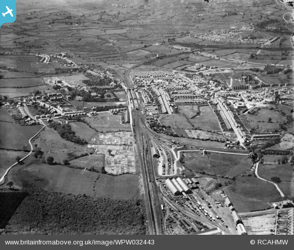
WPW032443 WALES (1930). General view of Caerphilly, oblique aerial view. 5"x4" black and white glass plate negative.
© Copyright OpenStreetMap contributors and licensed by the OpenStreetMap Foundation. 2026. Cartography is licensed as CC BY-SA.
Nearby Images (33)
Details
| Title | [WPW032443] General view of Caerphilly, oblique aerial view. 5"x4" black and white glass plate negative. |
| Reference | WPW032443 |
| Date | 1930 |
| Link | Coflein Archive Item 6370760 |
| Place name | |
| Parish | |
| District | |
| Country | WALES |
| Easting / Northing | 315700, 186920 |
| Longitude / Latitude | -3.2165926156352, 51.574361161326 |
| National Grid Reference | ST157869 |
Pins

Handymanathome |
Monday 30th of March 2020 04:02:47 PM | |

Penrhos1920 |
Thursday 21st of March 2013 07:15:46 PM | |

Penrhos1920 |
Thursday 21st of March 2013 07:12:19 PM | |

Penrhos1920 |
Thursday 21st of March 2013 07:10:58 PM | |

Penrhos1920 |
Thursday 21st of March 2013 07:09:46 PM | |

pratjeffley |
Wednesday 19th of September 2012 02:22:38 AM | |

pratjeffley |
Wednesday 19th of September 2012 02:17:54 AM | |

pratjeffley |
Wednesday 19th of September 2012 02:14:38 AM | |
I think these were the carriage & wagon shops, replaced before WW2 by new buildings. The loco shops are just barely in view at bottom of picture |

gBr |
Saturday 26th of September 2015 08:10:23 PM |

pratjeffley |
Wednesday 19th of September 2012 02:09:38 AM | |

johnabutt |
Saturday 7th of July 2012 03:27:32 PM | |
This is actually a footpath (which still exists) linking Nant-y-calch Farm to the area locally known as 'The Clay Pits'--the area south of the Wernddu brickworks. |

pratjeffley |
Wednesday 19th of September 2012 02:06:02 AM |

johnabutt |
Saturday 7th of July 2012 03:26:35 PM |
User Comment Contributions
Van Road, Caerphilly, 25/09/2015 |

Class31 |
Sunday 27th of September 2015 12:00:15 PM |


![[WAW007641] View of Caerphilly showing castle. Oblique aerial photograph, 5½" cut roll film.](http://britainfromabove.org.uk/sites/all/libraries/aerofilms-images/public/100x100/WAW/007/WAW007641.jpg)
![[WAW007642] View of Caerphilly showing castle. Oblique aerial photograph, 5½" cut roll film.](http://britainfromabove.org.uk/sites/all/libraries/aerofilms-images/public/100x100/WAW/007/WAW007642.jpg)
![[WAW007643] View of Caerphilly showing castle. Oblique aerial photograph, 5½" cut roll film.](http://britainfromabove.org.uk/sites/all/libraries/aerofilms-images/public/100x100/WAW/007/WAW007643.jpg)
![[WAW007644] View of Caerphilly showing castle. Oblique aerial photograph, 5½" cut roll film.](http://britainfromabove.org.uk/sites/all/libraries/aerofilms-images/public/100x100/WAW/007/WAW007644.jpg)
![[WAW007647] View of Caerphilly showing castle. Oblique aerial photograph, 5½" cut roll film.](http://britainfromabove.org.uk/sites/all/libraries/aerofilms-images/public/100x100/WAW/007/WAW007647.jpg)
![[WAW018008] View of Caerphilly showing castle and housing estates. Oblique aerial photograph, 5½" cut roll film.](http://britainfromabove.org.uk/sites/all/libraries/aerofilms-images/public/100x100/WAW/018/WAW018008.jpg)
![[WAW018009] View of Caerphilly showing castle and housing estates. Oblique aerial photograph, 5½" cut roll film.](http://britainfromabove.org.uk/sites/all/libraries/aerofilms-images/public/100x100/WAW/018/WAW018009.jpg)
![[WAW018010] View of Caerphilly showing castle and housing estates. Oblique aerial photograph, 5½" cut roll film.](http://britainfromabove.org.uk/sites/all/libraries/aerofilms-images/public/100x100/WAW/018/WAW018010.jpg)
![[WAW018660] View of three new factories at Virginia Park, Caerphilly](http://britainfromabove.org.uk/sites/all/libraries/aerofilms-images/public/100x100/WAW/018/WAW018660.jpg)
![[WAW018661] View of three new factories at Virginia Park, Caerphilly, showing the sports ground](http://britainfromabove.org.uk/sites/all/libraries/aerofilms-images/public/100x100/WAW/018/WAW018661.jpg)
![[WAW018662] View of three new factories at Virginia Park, Caerphilly](http://britainfromabove.org.uk/sites/all/libraries/aerofilms-images/public/100x100/WAW/018/WAW018662.jpg)
![[WAW018663] View of three new factories at Virginia Park, Caerphilly](http://britainfromabove.org.uk/sites/all/libraries/aerofilms-images/public/100x100/WAW/018/WAW018663.jpg)
![[WAW018664] View of three new factories at Virginia Park, Caerphilly](http://britainfromabove.org.uk/sites/all/libraries/aerofilms-images/public/100x100/WAW/018/WAW018664.jpg)
![[WAW018665] View of three new factories at Virginia Park, Caerphilly](http://britainfromabove.org.uk/sites/all/libraries/aerofilms-images/public/100x100/WAW/018/WAW018665.jpg)
![[WAW018666] View of three new factories at Virginia Park, Caerphilly](http://britainfromabove.org.uk/sites/all/libraries/aerofilms-images/public/100x100/WAW/018/WAW018666.jpg)
![[WAW018667] View of three new factories at Virginia Park, Caerphilly](http://britainfromabove.org.uk/sites/all/libraries/aerofilms-images/public/100x100/WAW/018/WAW018667.jpg)
![[WAW018668] View of three new factories at Virginia Park, Caerphilly](http://britainfromabove.org.uk/sites/all/libraries/aerofilms-images/public/100x100/WAW/018/WAW018668.jpg)
![[WPW013836] View of Caerphilly showing castle. Oblique aerial photograph, 5"x4" BW glass plate.](http://britainfromabove.org.uk/sites/all/libraries/aerofilms-images/public/100x100/WPW/013/WPW013836.jpg)
![[WPW032443] General view of Caerphilly, oblique aerial view. 5"x4" black and white glass plate negative.](http://britainfromabove.org.uk/sites/all/libraries/aerofilms-images/public/100x100/WPW/032/WPW032443.jpg)
![[WPW032444] General view of Caerphilly, showing castle, oblique aerial view. 5"x4" black and white glass plate negative.](http://britainfromabove.org.uk/sites/all/libraries/aerofilms-images/public/100x100/WPW/032/WPW032444.jpg)
![[WPW032445] General view of Caerphilly, oblique aerial view. 5"x4" black and white glass plate negative.](http://britainfromabove.org.uk/sites/all/libraries/aerofilms-images/public/100x100/WPW/032/WPW032445.jpg)
![[WPW032447] General view of Caerphilly, oblique aerial view. 5"x4" black and white glass plate negative.](http://britainfromabove.org.uk/sites/all/libraries/aerofilms-images/public/100x100/WPW/032/WPW032447.jpg)
![[WPW050477] View of Caerphilly showing school, allotments and castle. Oblique aerial photograph, 5"x4" BW glass plate.](http://britainfromabove.org.uk/sites/all/libraries/aerofilms-images/public/100x100/WPW/050/WPW050477.jpg)
![[WPW050478] View of Caerphilly showing school, allotments and castle. Oblique aerial photograph, 5"x4" BW glass plate.](http://britainfromabove.org.uk/sites/all/libraries/aerofilms-images/public/100x100/WPW/050/WPW050478.jpg)
![[WPW050479] View of Caerphilly showing castle. Oblique aerial photograph, 5"x4" BW glass plate.](http://britainfromabove.org.uk/sites/all/libraries/aerofilms-images/public/100x100/WPW/050/WPW050479.jpg)
![[WPW050481] View of Caerphilly showing castle. Oblique aerial photograph, 5"x4" BW glass plate.](http://britainfromabove.org.uk/sites/all/libraries/aerofilms-images/public/100x100/WPW/050/WPW050481.jpg)
![[WPW050482] View of Caerphilly showing castle. Oblique aerial photograph, 5"x4" BW glass plate.](http://britainfromabove.org.uk/sites/all/libraries/aerofilms-images/public/100x100/WPW/050/WPW050482.jpg)
![[WAW005950] View of Caerphilly showing castle and school](http://britainfromabove.org.uk/sites/all/libraries/aerofilms-images/public/100x100/WAW/005/WAW005950.jpg)
![[WAW005951] View of Caerphilly showing castle and new housing under construction](http://britainfromabove.org.uk/sites/all/libraries/aerofilms-images/public/100x100/WAW/005/WAW005951.jpg)
![[WAW005952] View of Caerphilly showing castle](http://britainfromabove.org.uk/sites/all/libraries/aerofilms-images/public/100x100/WAW/005/WAW005952.jpg)
![[WAW005953] View of Caerphilly showing castle](http://britainfromabove.org.uk/sites/all/libraries/aerofilms-images/public/100x100/WAW/005/WAW005953.jpg)
![[WAW005954] View of Caerphilly showing castle](http://britainfromabove.org.uk/sites/all/libraries/aerofilms-images/public/100x100/WAW/005/WAW005954.jpg)
![[WAW005955] View of Caerphilly showing castle](http://britainfromabove.org.uk/sites/all/libraries/aerofilms-images/public/100x100/WAW/005/WAW005955.jpg)