
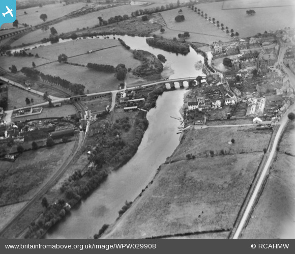
WPW029908 WALES (1929). View of Wye Bridge, Monmouth, oblique aerial view. 5"x4" black and white glass plate negative.
© Copyright OpenStreetMap contributors and licensed by the OpenStreetMap Foundation. 2026. Cartography is licensed as CC BY-SA.
Nearby Images (48)
WAW007084

WAW007085

WAW007086

WAW007087

WAW007088

WAW007089

WAW016142

WAW016143

WPW006051

WPW006052

WPW006053

WPW006054

WPW006055

WPW006056

WPW006057

WPW006058

WPW006059

WPW029894

WPW029895

WPW029896

WPW029902

WPW029903

WPW029904

WPW029908

WPW039974

WPW039975

WPW039976

WPW039977

WPW048170

WPW048171

WPW048172

WPW048173

WPW048174

WPW048175

WPW048176

WPW048177

WPW048178

WPW048179

WPW048180

WPW048181

WPW058582

WPW058583

WPW058584

WPW058585

WPW058586

WPW058587

WPW058588

WPW029905

Details
| Title | [WPW029908] View of Wye Bridge, Monmouth, oblique aerial view. 5"x4" black and white glass plate negative. |
| Reference | WPW029908 |
| Date | 1929 |
| Link | Coflein Archive Item 6370708 |
| Place name | |
| Parish | |
| District | |
| Country | WALES |
| Easting / Northing | 350740, 212819 |
| Longitude / Latitude | -2.7146209238032, 51.811384535538 |
| National Grid Reference | SO507128 |
Pins

brian |
Friday 3rd of August 2012 01:24:02 AM | |
|
brian |
Friday 3rd of August 2012 01:22:13 AM | |
|
brian |
Friday 3rd of August 2012 01:21:14 AM | |

Class31 |
Tuesday 3rd of July 2012 08:49:32 PM | |
|
Class31 |
Tuesday 3rd of July 2012 08:47:53 PM | |
|
Class31 |
Tuesday 3rd of July 2012 08:46:34 PM | |
|
Class31 |
Tuesday 3rd of July 2012 08:45:10 PM |
User Comment Contributions
Dear all, we have now verified and corrected the image's identity to Monmouth following your extremely helpful comments. Thank you very much for your contributions. Natasha Scullion Britain from Above Activity Officer |
Natasha Scullion |
Friday 31st of August 2012 05:02:51 PM |

This is another incorrectly identified image which Shows Monmouth when it has been attributed to being Abergavenny. There was no Station at Abergavenny alongside the River Usk. It Monmouth the station was alongside the River Wye as shown. |
Class31 |
Tuesday 14th of August 2012 10:31:32 PM |
you are right it is usk |
judgejeffriesjones |
Tuesday 14th of August 2012 10:31:32 PM |
This is Monmouth, with May Hill Station centre left. |
Allan |
Monday 2nd of July 2012 12:19:02 AM |
Not Abergavenny - looks like Monmouth to me |
Matt |
Tuesday 26th of June 2012 07:00:10 PM |
That makes better sense lol |
steve |
Tuesday 26th of June 2012 03:16:27 PM |
I cant think of any where in Abergavenny where the railway ran next to the river. Im not sure this is Abergavenny |
steve |
Tuesday 26th of June 2012 02:47:53 PM |
You are right - it's Monmouth, long before the trunk road was built on the bank of the Wye. |
Dick Cole |
Tuesday 26th of June 2012 02:47:53 PM |