
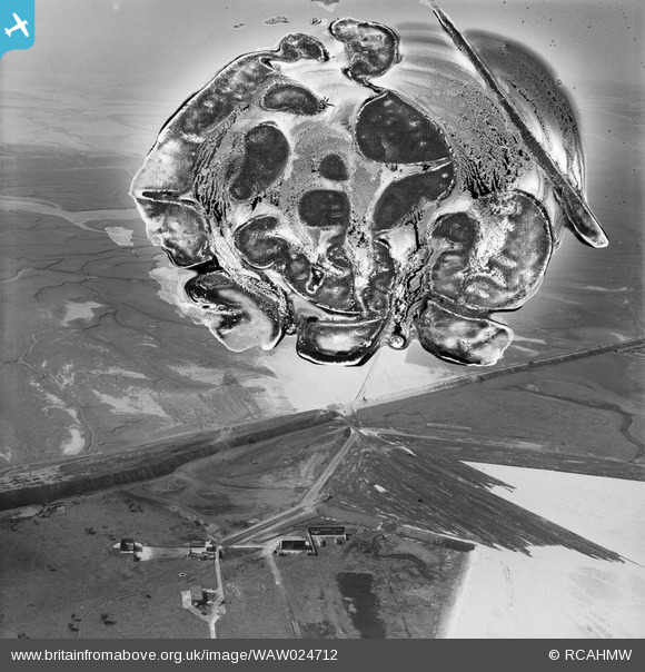
WAW024712 WALES (1949). View of the dredging of the Shotton steelworks site (commissioned by Westminster Dredging Co.)
© Copyright OpenStreetMap contributors and licensed by the OpenStreetMap Foundation. 2026. Cartography is licensed as CC BY-SA.
Nearby Images (48)
WAW024712
")
WAW024713
")
WAW024714
")
WAW024715
")
WAW024716
")
WAW024717
")
WAW024718
")
WAW024719
")
WAW024720
")
WAW024721
")
WAW024722
")
WAW027362
. Oblique aerial photograph, 5½\" cut roll film.")
WAW027366

WAW027367

WAW027370

WAW027382
. Oblique aerial photograph, 5½\" cut roll film.")
WAW027383
. Oblique aerial photograph, 5½\" cut roll film.")
WAW027384
. Oblique aerial photograph, 5½\" cut roll film.")
WAW030308

WAW030309

WAW030310

WAW030311

WAW030312

WAW030313

WAW030314

WAW030315

WAW030316
, for Shotton Steelworks commissioned by the Westminster Dredging Co. Ltd")
WAW030317
, for Shotton Steelworks commissioned by the Westminster Dredging Co. Ltd")
WAW030318
, for Shotton Steelworks commissioned by the Westminster Dredging Co. Ltd")
WAW030319

WAW030320

WAW030321

WAW030322

WAW030323

WAW030324

WAW030325

WAW030326

WAW030327

WAW030328

WAW030329

WAW030330

WAW030331

WAW030332

WAW030333
, for Shotton Steelworks commissioned by the Westminster Dredging Co. Ltd")
WAW030334

WAW030335

WAW030336

WAW030337

Details
| Title | [WAW024712] View of the dredging of the Shotton steelworks site (commissioned by Westminster Dredging Co.) |
| Reference | WAW024712 |
| Date | 12-July-1949 |
| Link | Coflein Archive Item 6414074 |
| Place name | |
| Parish | |
| District | |
| Country | WALES |
| Easting / Northing | 330500, 370500 |
| Longitude / Latitude | -3.0411853684416, 53.226709296404 |
| National Grid Reference | SJ305705 |
Pins

Matt Aldred edob.mattaldred.com |
Sunday 6th of December 2020 08:03:21 PM |
User Comment Contributions
Broken Bank, showing area where sand was dumped to create a raised section near to the current shooting range (see bank also created at right angles to the Broken Bank). Now it is the model aircraft area. The bottom buildings are part of the Sealand shooting ranges that are now covered over. |

e10694 |
Monday 3rd of November 2014 08:31:47 PM |