
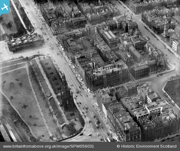
SPW056031 SCOTLAND (1937). Jenners, Princes Street and East Princes Street Gardens, Edinburgh. An oblique aerial photograph taken facing west.
© Copyright OpenStreetMap contributors and licensed by the OpenStreetMap Foundation. 2026. Cartography is licensed as CC BY-SA.
Nearby Images (19)
SPW056031

SPW056032

SPW056027

SPW056028

SPW056029

SPW056030

SPW027323

SAW010258

SPW027321

SPW027317

SPW027322

SPW027133

SAW010245

SPW027320

SAR010381

SAR010388

SPW027343

SAW009818

SPW027135

Details
| Title | [SPW056031] Jenners, Princes Street and East Princes Street Gardens, Edinburgh. An oblique aerial photograph taken facing west. |
| Reference | SPW056031 |
| Date | 1937 |
| Link | NRHE Collection item 1258145 |
| Place name | |
| Parish | EDINBURGH (EDINBURGH, CITY OF) |
| District | CITY OF EDINBURGH |
| Country | SCOTLAND |
| Easting / Northing | 325511, 673959 |
| Longitude / Latitude | -3.1930479263607, 55.952919064316 |
| National Grid Reference | NT255740 |
Pins
Be the first to add a comment to this image!