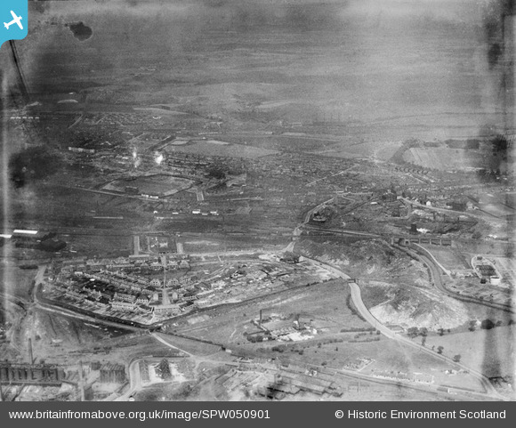
SPW050901 SCOTLAND (1936). Coatbridge, general view, showing Cliftonhill Stadium and Dunbeth Public Park. An oblique aerial photograph taken facing north. This image has been produced from a damaged negative.
    © Copyright OpenStreetMap contributors and licensed by the OpenStreetMap Foundation. 2025. Cartography is licensed as CC BY-SA.
  
Nearby Images (12)
Details
| Title | [SPW050901] Coatbridge, general view, showing Cliftonhill Stadium and Dunbeth Public Park. An oblique aerial photograph taken facing north. This image has been produced from a damaged negative. | 
| Reference | SPW050901 | 
| Date | 1936 | 
| Link | NRHE Collection item 1257879 | 
| Place name | |
| Parish | OLD MONKLAND (MONKLANDS) | 
| District | MONKLANDS | 
| Country | SCOTLAND | 
| Easting / Northing | 274333, 664784 | 
| Longitude / Latitude | -4.0080214858705, 55.859867642125 | 
| National Grid Reference | NS743648 | 
Pins
|  Rochsoloch iron works |   jaypea | Thursday 14th of April 2016 05:57:37 PM | 
|  The Calder |   jaypea | Monday 4th of April 2016 05:47:29 PM | 
|  Stewart,s Land |   jaypea | Monday 4th of April 2016 05:46:30 PM | 
|  Albion Rovers Stand |   jaypea | Monday 4th of April 2016 05:44:22 PM | 
|  The Tech. |   jaypea | Thursday 17th of March 2016 06:24:46 PM | 
|  Sewage Plant |   jaypea | Thursday 3rd of March 2016 08:13:54 PM | 
|  The Waverly |   jaypea | Thursday 3rd of March 2016 08:04:23 PM | 
|  Sheepford Boiler Works |   jaypea | Thursday 3rd of March 2016 07:59:51 PM | 
|  Sikeside St. |   jaypea | Thursday 3rd of March 2016 07:50:50 PM | 
|  Carnbroe Iron Works |   jaypea | Thursday 3rd of March 2016 07:38:55 PM | 
|  All Saints Chapel |   jaypea | Wednesday 2nd of March 2016 06:02:32 PM | 
|  Carnbroe |   jaypea | Wednesday 2nd of March 2016 05:55:03 PM | 
|  Beechwood Dr. Greenwood Cresc. Southfield Cresc. during construction |   jaypea | Sunday 28th of February 2016 05:37:10 PM | 
|  Kildonan School |   jaypea | Sunday 24th of January 2016 06:01:23 PM | 
|  St. Pat,s School |   jaypea | Sunday 24th of January 2016 06:00:45 PM | 
|  Burnbank St. |   jaypea | Sunday 24th of January 2016 05:59:08 PM | 
|  The Boundary Bar |   jaypea | Sunday 24th of January 2016 05:56:27 PM | 
|  The Model |   jaypea | Sunday 24th of January 2016 05:53:42 PM | 
|  Coatdyke Cross |   jaypea | Sunday 24th of January 2016 05:49:08 PM | 
|  Railway Viaduct by Centenary Park |   jaypea | Sunday 24th of January 2016 05:45:21 PM | 
|  Coatdyke Station |   jaypea | Sunday 24th of January 2016 05:42:51 PM | 
|  Coatdyke Primary School |   jaypea | Sunday 24th of January 2016 05:38:33 PM | 
|  Monkland Canal |   jaypea | Sunday 24th of January 2016 05:36:48 PM | 
|  Kelvin St. |   jaypea | Sunday 24th of January 2016 05:36:05 PM | 
|  Partick St. |   jaypea | Sunday 24th of January 2016 05:35:14 PM | 
|  Calder Station |   jaypea | Sunday 24th of January 2016 05:34:27 PM | 
 
             
  ![[SPW050901] Coatbridge, general view, showing Cliftonhill Stadium and Dunbeth Public Park.  An oblique aerial photograph taken facing north.  This image has been produced from a damaged negative.](http://britainfromabove.org.uk/sites/all/libraries/aerofilms-images/public/100x100/SPW/050/SPW050901.jpg) 
  
                                          ![[SAW029956] Stewarts and Lloyds Ltd. Works, Main Street, Coatbridge.  An oblique aerial photograph taken facing south-east.  This image has been produced from a crop marked negative.](http://britainfromabove.org.uk/sites/all/libraries/aerofilms-images/public/100x100/SAW/029/SAW029956.jpg) 
 ![[SAW029957] Stewarts and Lloyds Ltd. Works, Main Street and Albion Rovers Football Ground, Coatbridge.  An oblique aerial photograph taken facing south.  This image has been produced from a crop marked negative.](http://britainfromabove.org.uk/sites/all/libraries/aerofilms-images/public/100x100/SAW/029/SAW029957.jpg) 
 ![[SAW029958] Stewarts and Lloyds Ltd. Works, Main Street and Albion Rovers Football Ground, Coatbridge.  An oblique aerial photograph taken facing south.  This image has been produced from a crop marked negative.](http://britainfromabove.org.uk/sites/all/libraries/aerofilms-images/public/100x100/SAW/029/SAW029958.jpg) 
 ![[SAW029959] Stewarts and Lloyds Ltd. Works, Main Street, Coatbridge.  An oblique aerial photograph taken facing south-east.  This image has been produced from a crop marked negative.](http://britainfromabove.org.uk/sites/all/libraries/aerofilms-images/public/100x100/SAW/029/SAW029959.jpg) 
 ![[SAW029960] Stewarts and Lloyds Ltd. Works, Main Street, Coatbridge.  An oblique aerial photograph taken facing west.  This image has been produced from a crop marked negative.](http://britainfromabove.org.uk/sites/all/libraries/aerofilms-images/public/100x100/SAW/029/SAW029960.jpg) 
 ![[SAW029961] Coatbridge, general view, showing Stewarts and Lloyds Ltd. Works, Main Street and Calder Station.  An oblique aerial photograph taken facing south.](http://britainfromabove.org.uk/sites/all/libraries/aerofilms-images/public/100x100/SAW/029/SAW029961.jpg) 
 ![[SAW029962] Stewarts and Lloyds Ltd. Works, Main Street and Albion Rovers Football Ground, Coatbridge.  An oblique aerial photograph taken facing west.  This image has been produced from a crop marked negative.](http://britainfromabove.org.uk/sites/all/libraries/aerofilms-images/public/100x100/SAW/029/SAW029962.jpg) 
 ![[SAW029963] Coatbridge, general view, showing Stewarts and Lloyds Ltd. Works, Main Street and Albion Rovers Football Ground.  An oblique aerial photograph taken facing north.  This image has been produced from a crop marked negative.](http://britainfromabove.org.uk/sites/all/libraries/aerofilms-images/public/100x100/SAW/029/SAW029963.jpg) 
 ![[SAW029964] Coatbridge, general view, showing Stewarts and Lloyds Ltd. Works, Main Street and East Stewart Street.  An oblique aerial photograph taken facing north-east.  This image has been produced from a crop marked negative.](http://britainfromabove.org.uk/sites/all/libraries/aerofilms-images/public/100x100/SAW/029/SAW029964.jpg) 
 ![[SAW029965] Stewarts and Lloyds Ltd. Works, Main Street, Coatbridge.  An oblique aerial photograph taken facing south-west.](http://britainfromabove.org.uk/sites/all/libraries/aerofilms-images/public/100x100/SAW/029/SAW029965.jpg) 
 ![[SPW050888] Coatbridge, general view, showing Cliftonhill Stadium and Dunbeth Public Park.  An oblique aerial photograph taken facing north.](http://britainfromabove.org.uk/sites/all/libraries/aerofilms-images/public/100x100/SPW/050/SPW050888.jpg)