
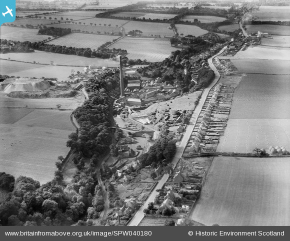
SPW040180 SCOTLAND (1932). Currie, general view, showing Lanark Road and Kinleith Paper Mills. An oblique aerial photograph taken facing west.
© Copyright OpenStreetMap contributors and licensed by the OpenStreetMap Foundation. 2026. Cartography is licensed as CC BY-SA.
Nearby Images (8)
SPW040180

SPW040176

SPW040179

SAR029093

SPW040175

SPW040177

SPW040178

SAR010319

Details
| Title | [SPW040180] Currie, general view, showing Lanark Road and Kinleith Paper Mills. An oblique aerial photograph taken facing west. |
| Reference | SPW040180 |
| Date | 1932 |
| Link | NRHE Collection item 1257268 |
| Place name | |
| Parish | CURRIE |
| District | CITY OF EDINBURGH |
| Country | SCOTLAND |
| Easting / Northing | 319134, 668145 |
| Longitude / Latitude | -3.2934155474282, 55.899657764628 |
| National Grid Reference | NT191681 |
Pins

macvidi |
Sunday 28th of December 2025 08:04:42 PM | |
|
macvidi |
Sunday 28th of December 2025 07:46:07 PM | |
|
esdxc37 |
Sunday 11th of January 2015 07:10:31 PM | |
|
ht247 |
Saturday 11th of October 2014 10:39:07 PM | |
|
ht247 |
Saturday 11th of October 2014 10:37:51 PM | |
|
ht247 |
Saturday 11th of October 2014 10:37:32 PM | |
|
ht247 |
Saturday 11th of October 2014 10:35:07 PM | |
|
ht247 |
Saturday 11th of October 2014 10:31:15 PM | |
|
Andy A |
Monday 21st of April 2014 12:19:18 AM |