
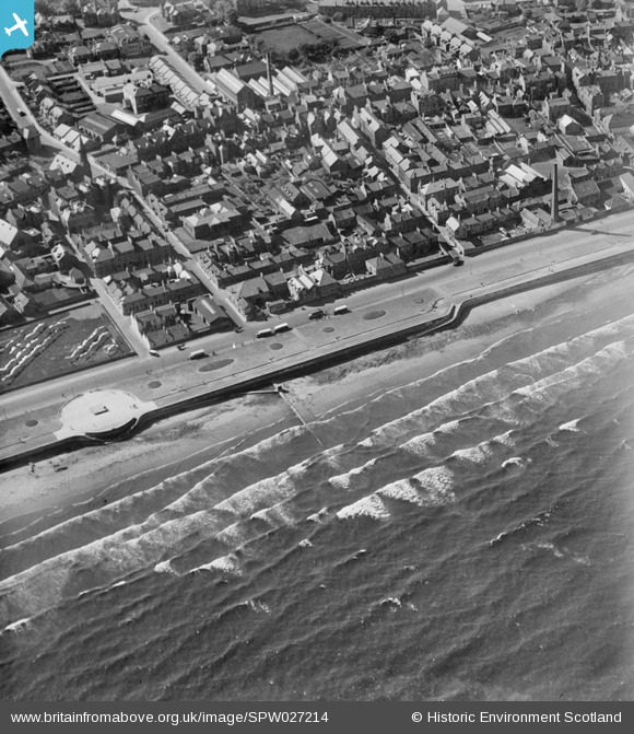
SPW027214 SCOTLAND (1929). Kirkcaldy, general view, showing Esplanade and Charlotte Street. An oblique aerial photograph taken facing north-west.
© Copyright OpenStreetMap contributors and licensed by the OpenStreetMap Foundation. 2026. Cartography is licensed as CC BY-SA.
Nearby Images (3)
SPW027214

SAR023858

SAR031680

Details
| Title | [SPW027214] Kirkcaldy, general view, showing Esplanade and Charlotte Street. An oblique aerial photograph taken facing north-west. |
| Reference | SPW027214 |
| Date | 1929 |
| Link | NRHE Collection item 1256788 |
| Place name | |
| Parish | KIRKCALDY AND DYSART |
| District | KIRKCALDY |
| Country | SCOTLAND |
| Easting / Northing | 328039, 691215 |
| Longitude / Latitude | -3.1571967433485, 56.108330078313 |
| National Grid Reference | NT280912 |
Pins

stuart |
Sunday 12th of July 2020 12:25:48 PM | |
|
stuart |
Sunday 12th of July 2020 11:38:14 AM | |
|
stuart |
Sunday 12th of July 2020 11:33:14 AM | |
|
stuart |
Sunday 12th of July 2020 11:32:59 AM | |
|
stuart |
Sunday 12th of July 2020 11:32:15 AM | |
|
stuart |
Sunday 12th of July 2020 11:30:43 AM | |
|
stuart |
Sunday 12th of July 2020 11:29:42 AM | |
|
stuart |
Sunday 12th of July 2020 11:28:08 AM | |
|
stuart |
Sunday 12th of July 2020 11:24:17 AM | |
|
stuart |
Sunday 12th of July 2020 11:13:38 AM | |
|
Norman |
Friday 15th of January 2016 12:24:08 PM | |
|
Andrew |
Saturday 17th of October 2015 11:33:07 PM |
User Comment Contributions
The first road from the left is Glasswork Street. The second is Charlotte Street which then crosses the (almost hidden) High Street and continues as Whytehouse Avenue. Prior to the introduction of steam power in 1807, Kirkcaldy had more than 2000 hand looms producing linen. In the bottom left, the wavy lines are linen whitening in the sun on the bleachfields of Volunteers Green. This green space is the remnant of an area, originally of 9 acres, gifted to the town by Charles I in 1644. The area to the bottom of the picture was radically altered in the early 1970s by the construction of the Mercat Shopping Centre, municipal swimming pool and multi-story car park. I am fairly sure that the large brick chimney in the centre right was salt works. |
BillFerguson |
Tuesday 26th of June 2012 02:41:10 PM |