
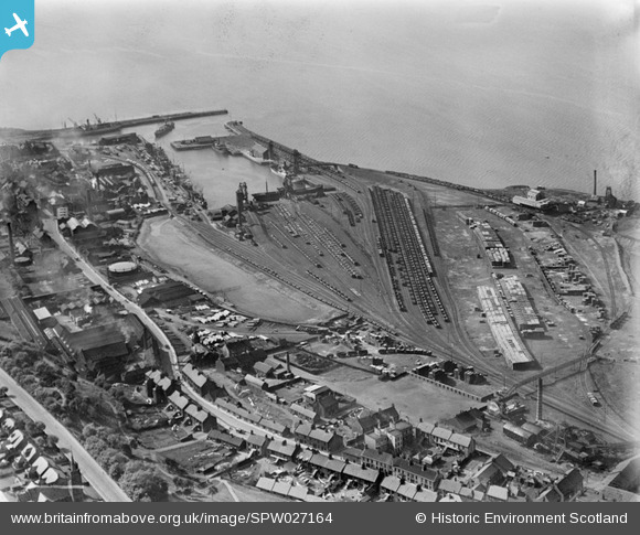
SPW027164 SCOTLAND (1929). Bo'ness, general view, showing railway sidings, Dock and Timber Basin. An oblique aerial photograph taken facing north-west.
© Copyright OpenStreetMap contributors and licensed by the OpenStreetMap Foundation. 2025. Cartography is licensed as CC BY-SA.
Nearby Images (2)
SPW027164

SPW027162

Details
| Title | [SPW027164] Bo'ness, general view, showing railway sidings, Dock and Timber Basin. An oblique aerial photograph taken facing north-west. |
| Reference | SPW027164 |
| Date | 1929 |
| Link | Canmore Collection item 1256738 |
| Place name | |
| Parish | BO'NESS AND CARRIDEN |
| District | FALKIRK |
| Country | SCOTLAND |
| Easting / Northing | 300389, 681708 |
| Longitude / Latitude | -3.5981280058079, 56.017972030326 |
| National Grid Reference | NT004817 |
Pins

Andy A |
Sunday 5th of January 2014 04:57:57 PM | |
|
MB |
Saturday 15th of September 2012 11:44:32 AM | |
|
MB |
Saturday 15th of September 2012 11:42:17 AM | |
|
MB |
Saturday 15th of September 2012 11:41:43 AM | |
|
MB |
Saturday 15th of September 2012 11:41:08 AM | |
|
MB |
Saturday 15th of September 2012 11:38:59 AM | |
|
MB |
Saturday 15th of September 2012 11:38:36 AM | |
|
MB |
Saturday 15th of September 2012 11:36:35 AM | |
|
MB |
Saturday 15th of September 2012 11:36:10 AM | |
|
MB |
Saturday 15th of September 2012 11:34:33 AM | |
|
MB |
Saturday 15th of September 2012 11:32:53 AM | |
|
MB |
Saturday 15th of September 2012 11:13:29 AM | |
|
MB |
Saturday 15th of September 2012 11:07:47 AM | |
|
MB |
Saturday 15th of September 2012 11:06:55 AM | |
|
MB |
Saturday 15th of September 2012 11:06:21 AM | |
|
MB |
Saturday 15th of September 2012 11:01:47 AM | |
|
cell |
Saturday 28th of July 2012 01:46:05 PM |
User Comment Contributions
By 1954 the Grange Colliery had closed and only old shafts were marked on the OS map. The Western Field Colliery had expanded and was then being worked as the Carriden Colliery |
MB |
Saturday 15th of September 2012 11:11:38 AM |