
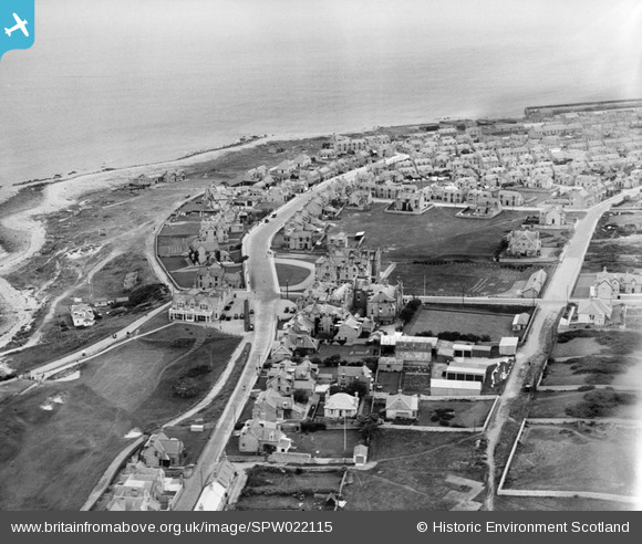
SPW022115 SCOTLAND (1928). An oblique aerial photograph taken facing north-east showing Moray Golf Course Club House and Stotfield Road, Lossiemouth in 1928.
© Copyright OpenStreetMap contributors and licensed by the OpenStreetMap Foundation. 2026. Cartography is licensed as CC BY-SA.
Nearby Images (2)
SPW022115

SPW040548

Details
| Title | [SPW022115] An oblique aerial photograph taken facing north-east showing Moray Golf Course Club House and Stotfield Road, Lossiemouth in 1928. |
| Reference | SPW022115 |
| Date | 1928 |
| Link | NRHE Collection item 1256488 |
| Place name | |
| Parish | DRAINIE |
| District | MORAY |
| Country | SCOTLAND |
| Easting / Northing | 322981, 870884 |
| Longitude / Latitude | -3.2931398373036, 57.721369606949 |
| National Grid Reference | NJ230709 |
Pins

Chris B |
Friday 25th of December 2015 04:39:26 PM |
User Comment Contributions
Building in centre with driveway is the Marine Hotel, not long then completed as a support for the less visible Stotfield hotel across the road, with the Bowling Green to the south. The open space centre right is the Big Greenie used for drying herring nets, of which there were very many. It became the Marine Park about 1936 or so, and was abandoned by the Moray Council in a fit of money saving in the 1990's |
Donnie |
Sunday 1st of December 2013 08:31:33 PM |