
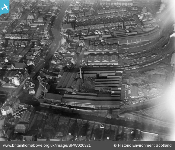
SPW020321 SCOTLAND (1928). Falkirk, general view, showing Springfield Saw Mills, Grahams Road. An oblique aerial photograph taken facing north.
© Copyright OpenStreetMap contributors and licensed by the OpenStreetMap Foundation. 2025. Cartography is licensed as CC BY-SA.
Nearby Images (2)
SPW020321

SPW020264

Details
| Title | [SPW020321] Falkirk, general view, showing Springfield Saw Mills, Grahams Road. An oblique aerial photograph taken facing north. |
| Reference | SPW020321 |
| Date | 1928 |
| Link | Canmore Collection item 1259351 |
| Place name | |
| Parish | FALKIRK |
| District | FALKIRK |
| Country | SCOTLAND |
| Easting / Northing | 288980, 680480 |
| Longitude / Latitude | -3.7805685376438, 56.004436429557 |
| National Grid Reference | NS890805 |
Pins
 buchanan |
Wednesday 29th of May 2013 11:32:12 PM | |
buchanan |
Saturday 15th of December 2012 07:31:48 PM | |
The Graham and Morton building at the bottom left of this picture was a large furniture and housewares shop. It sold high quality goods that were not readily available elsewhere. I recall that my mother bought curtains from there once. McCready's fish and chip shop was around the corner from Graham and Morton - I used to deliver pies, black puddings and haggis to Mr and Mrs McCready when I worked as a delivery van driver for Newtons in Brightons next to Goodfellow's garage. There was also a garage and car showroom around the corner from Graham and Morton - we bought an Opel Ascona from there in the late 1970's or early 1980's. Shortly after that this part of Falkirk changed forever when the ground levels were raised in connection with the construction of the roundabout at the bottom of Vicar Street together with the new railway bridge at Grahamston station. |
Alex Cameron |
Sunday 2nd of March 2014 03:51:20 PM |
Cailean |
Thursday 28th of June 2012 07:07:50 PM |