
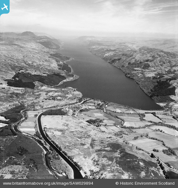
SAW029894 SCOTLAND (1950). Fort Augustus, general view, showing Caledonian Canal and Loch Ness. An oblique aerial photograph taken facing north-east.
© Copyright OpenStreetMap contributors and licensed by the OpenStreetMap Foundation. 2026. Cartography is licensed as CC BY-SA.
Nearby Images (2)
SAW029894

SPW022094

Details
| Title | [SAW029894] Fort Augustus, general view, showing Caledonian Canal and Loch Ness. An oblique aerial photograph taken facing north-east. |
| Reference | SAW029894 |
| Date | 1950 |
| Link | NRHE Collection item 1269542 |
| Place name | |
| Parish | BOLESKINE AND ABERTARFF |
| District | INVERNESS |
| Country | SCOTLAND |
| Easting / Northing | 238316, 809266 |
| Longitude / Latitude | -4.6726848048211, 57.145947926743 |
| National Grid Reference | NH383093 |
Pins
Dawg |
Tuesday 5th of September 2023 10:24:19 AM | |

JMB |
Saturday 3rd of May 2014 10:36:39 PM | |

Andy A |
Tuesday 7th of January 2014 03:29:16 PM | |
|
Andy A |
Tuesday 7th of January 2014 03:27:10 PM |
User Comment Contributions

Two Nissen huts used to transfer ammunition from the railway line to lorries but no more known about the purpose. |
JMB |
Saturday 3rd of May 2014 10:37:37 PM |
|
The hiding place of the Zygon's ship in the 4th Doctor's story; The Terror of the Zygons. It gave us at least one explanation about the Loch Ness Monster! |
Natasha Scullion |
Wednesday 5th of February 2014 05:34:35 PM |
Two Nissen huts can be seen by the railway near the centre of the image. These might have been a RNAD. Canmore ID 299485 Site Number NH30NE 87 NGR NH 37406 08582 |
JMB |
Tuesday 26th of June 2012 12:21:26 AM |