
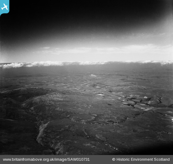
SAW010731 SCOTLAND (1947). Nithsdale, general view showing the valley of the River Nith between Kirkconnel and New Cumnock’. An oblique aerial photograph taken facing west.
© Copyright OpenStreetMap contributors and licensed by the OpenStreetMap Foundation. 2026. Cartography is licensed as CC BY-SA.
Details
| Title | [SAW010731] Nithsdale, general view showing the valley of the River Nith between Kirkconnel and New Cumnock’. An oblique aerial photograph taken facing west. |
| Reference | SAW010731 |
| Date | 1947 |
| Link | NRHE Collection item 1268723 |
| Place name | |
| Parish | KIRKCONNEL |
| District | NITHSDALE |
| Country | SCOTLAND |
| Easting / Northing | 269000, 610000 |
| Longitude / Latitude | -4.0671201742292, 55.366466711694 |
| National Grid Reference | NS690100 |
Pins

Class31 |
Thursday 20th of September 2012 02:26:33 PM | |
|
Class31 |
Thursday 20th of September 2012 02:19:52 PM | |
|
Class31 |
Thursday 20th of September 2012 02:19:11 PM | |
|
Class31 |
Thursday 20th of September 2012 02:13:31 PM | |
|
Class31 |
Thursday 20th of September 2012 02:11:40 PM | |
|
Class31 |
Thursday 20th of September 2012 02:07:10 PM | |
|
Class31 |
Thursday 20th of September 2012 02:03:43 PM | |
|
Class31 |
Thursday 20th of September 2012 02:02:28 PM | |
|
Class31 |
Thursday 20th of September 2012 02:01:28 PM | |
|
Class31 |
Thursday 20th of September 2012 01:59:47 PM | |
|
Class31 |
Thursday 20th of September 2012 01:58:32 PM | |
|
Class31 |
Thursday 20th of September 2012 01:49:35 PM | |
|
Class31 |
Thursday 20th of September 2012 01:44:43 PM |
User Comment Contributions
Well not quite Newton Stewart but Kirkconnel some 50 miles distant. I had identified that there was a railway in shot some time ago but I had been looking closer to Newton Stewart. Today I was lucky and it all came together. Polneul was the decider for me when I discovered the traces of the white buildings. The A76, the railway and the River Nith were together and fitted. The field boundaries and the burns all fit. This is a confirmed identification. Today the area features a prominent wind farm which proves that even in this relatively remote area there are significant changes to the scene. |
Class31 |
Thursday 11th of October 2012 11:39:01 PM |
Thanks for Identification! I have checked this against the modern OS, and the field system and woodland around Glen Hall confirm the location for me. I have put in a request to update the record, and the corrected details will appear here in due course. Best wishes, Brian Wilkinson Britain from Above Activity Officer (Scotland). |

Brian Wilkinson |
Thursday 11th of October 2012 12:38:46 PM |
Thank you Brian for your kind comments. |
Class31 |
Thursday 11th of October 2012 11:39:01 PM |
This photo was said to be possibly near Newton Stewart which is 50 miles from its actual location near Kirkconnel. |
Class31 |
Friday 21st of September 2012 08:41:50 AM |
A view looking west over the valley of the River Nith between Kirkconnel and New Cumnock. |
Class31 |
Thursday 20th of September 2012 01:55:06 PM |
Eureka |
Class31 |
Thursday 20th of September 2012 01:32:14 PM |