
SAW010720 SCOTLAND (1947). Kinnoull Tower, Kinnoull Hill, Perth. An oblique aerial photograph taken facing west.

© Copyright OpenStreetMap contributors and licensed by the OpenStreetMap Foundation. 2026. Cartography is licensed as CC BY-SA.
Nearby Images (2)
SAW010720

SPW020107

Details
| Title | [SAW010720] Kinnoull Tower, Kinnoull Hill, Perth. An oblique aerial photograph taken facing west. |
| Reference | SAW010720 |
| Date | 1947 |
| Link | NRHE Collection item 1268713 |
| Place name | |
| Parish | KINFAUNS |
| District | PERTH AND KINROSS |
| Country | SCOTLAND |
| Easting / Northing | 313906, 722727 |
| Longitude / Latitude | -3.3946530779016, 56.389056386515 |
| National Grid Reference | NO139227 |
Pins

Arty |
Friday 7th of December 2012 08:42:16 PM |
User Comment Contributions
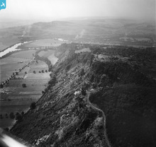
Kinnoull Hill is a good example of a 'scarp' feature - that is, a sudden change in the relative height of a landform, due to geological factors (in this case, a volcanic magma flow that has resisted weathering). |
AlMu |
Wednesday 7th of May 2014 10:21:39 AM |
|
Kinnoull Hill, 1947 |

heavenstobetsie |
Tuesday 26th of June 2012 09:38:01 AM |