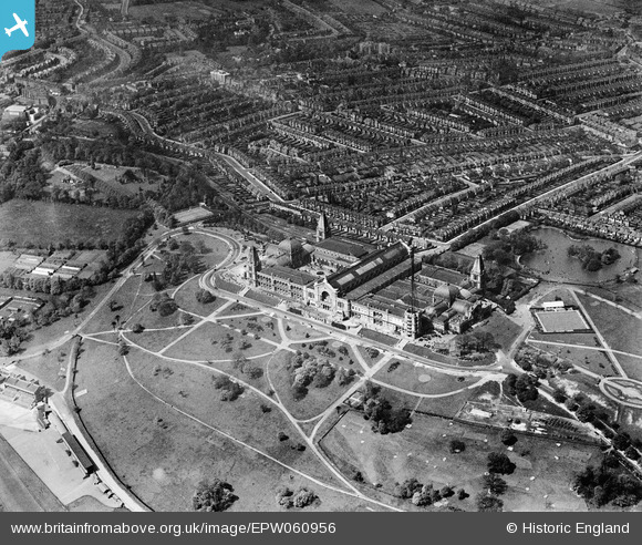
EPW060956 ENGLAND (1939). Alexandra Palace and environs, Alexandra Palace, 1939
© Copyright OpenStreetMap contributors and licensed by the OpenStreetMap Foundation. 2026. Cartography is licensed as CC BY-SA.
Nearby Images (21)
Details
| Title | [EPW060956] Alexandra Palace and environs, Alexandra Palace, 1939 |
| Reference | EPW060956 |
| Date | 12-May-1939 |
| Link | |
| Place name | ALEXANDRA PALACE |
| Parish | |
| District | |
| Country | ENGLAND |
| Easting / Northing | 529495, 189992 |
| Longitude / Latitude | -0.13034173696308, 51.593400590321 |
| National Grid Reference | TQ295900 |
Pins

Billy Turner |
Wednesday 30th of December 2015 09:05:56 PM | |

gBr |
Friday 26th of December 2014 01:35:26 AM | |

Robin |
Monday 16th of June 2014 01:16:47 AM | |

Alan McFaden |
Friday 23rd of August 2013 06:37:58 PM |


![[EPW060956] Alexandra Palace and environs, Alexandra Palace, 1939](http://britainfromabove.org.uk/sites/all/libraries/aerofilms-images/public/100x100/EPW/060/EPW060956.jpg)
![[EAW015854] Alexandra Palace, Wood Green, 1948. This image has been produced from a print.](http://britainfromabove.org.uk/sites/all/libraries/aerofilms-images/public/100x100/EAW/015/EAW015854.jpg)
![[EPW005788] Alexandra Palace, Muswell Hill, 1921](http://britainfromabove.org.uk/sites/all/libraries/aerofilms-images/public/100x100/EPW/005/EPW005788.jpg)
![[EAW022329] Alexandra Palace and environs, Muswell Hill, 1949](http://britainfromabove.org.uk/sites/all/libraries/aerofilms-images/public/100x100/EAW/022/EAW022329.jpg)
![[EPW024780] Alexandra Palace, Muswell Hill, 1928](http://britainfromabove.org.uk/sites/all/libraries/aerofilms-images/public/100x100/EPW/024/EPW024780.jpg)
![[EPW005787] Alexandra Palace, Muswell Hill, 1921](http://britainfromabove.org.uk/sites/all/libraries/aerofilms-images/public/100x100/EPW/005/EPW005787.jpg)
![[EPW046814] Alexandra Palace overlooking Alexandra Park Racecourse and Grandstand, Hornsey, 1935](http://britainfromabove.org.uk/sites/all/libraries/aerofilms-images/public/100x100/EPW/046/EPW046814.jpg)
![[EAW003047] Alexandra Palace, Muswell Hill, 1946](http://britainfromabove.org.uk/sites/all/libraries/aerofilms-images/public/100x100/EAW/003/EAW003047.jpg)
![[EPW005590] Alexandra Palace, London, 1921](http://britainfromabove.org.uk/sites/all/libraries/aerofilms-images/public/100x100/EPW/005/EPW005590.jpg)
![[EPW024778] Alexandra Palace, Muswell Hill, 1928](http://britainfromabove.org.uk/sites/all/libraries/aerofilms-images/public/100x100/EPW/024/EPW024778.jpg)
![[EPW024779] Alexandra Palace, Muswell Hill, 1928](http://britainfromabove.org.uk/sites/all/libraries/aerofilms-images/public/100x100/EPW/024/EPW024779.jpg)
![[EPW046818] Alexandra Palace overlooking Alexandra Park Racecourse and Grandstand, Hornsey, 1935](http://britainfromabove.org.uk/sites/all/libraries/aerofilms-images/public/100x100/EPW/046/EPW046818.jpg)
![[EPW005789] Alexandra Palace, Muswell Hill, from the south-west, 1921](http://britainfromabove.org.uk/sites/all/libraries/aerofilms-images/public/100x100/EPW/005/EPW005789.jpg)
![[EPW046809] Alexandra Palace overlooking Alexandra Park Racecourse and Grandstand, Hornsey, 1935](http://britainfromabove.org.uk/sites/all/libraries/aerofilms-images/public/100x100/EPW/046/EPW046809.jpg)
![[EAW022328] Alexandra Palace and environs, Muswell Hill, 1949](http://britainfromabove.org.uk/sites/all/libraries/aerofilms-images/public/100x100/EAW/022/EAW022328.jpg)
![[EPW026945] Alexandra Park and Palace, Muswell Hill, 1929](http://britainfromabove.org.uk/sites/all/libraries/aerofilms-images/public/100x100/EPW/026/EPW026945.jpg)
![[EPW046811] Alexandra Palace overlooking Alexandra Park Racecourse and Grandstand, Hornsey, 1935](http://britainfromabove.org.uk/sites/all/libraries/aerofilms-images/public/100x100/EPW/046/EPW046811.jpg)
![[EPW008882] Alexandra Palace, a race meeting in progress at the Alexandra Park racecourse, 1923](http://britainfromabove.org.uk/sites/all/libraries/aerofilms-images/public/100x100/EPW/008/EPW008882.jpg)
![[EPW006283] Alexandra Palace, Muswell Hill, 1921](http://britainfromabove.org.uk/sites/all/libraries/aerofilms-images/public/100x100/EPW/006/EPW006283.jpg)
![[EPW046812] Alexandra Palace overlooking Alexandra Park Racecourse and Grandstand, Hornsey, 1935](http://britainfromabove.org.uk/sites/all/libraries/aerofilms-images/public/100x100/EPW/046/EPW046812.jpg)
![[EPW026944] Alexandra Park and Palace, Muswell Hill, 1929](http://britainfromabove.org.uk/sites/all/libraries/aerofilms-images/public/100x100/EPW/026/EPW026944.jpg)

